Current Auction
From the Greatest Map Publisher of the Pacific Coast
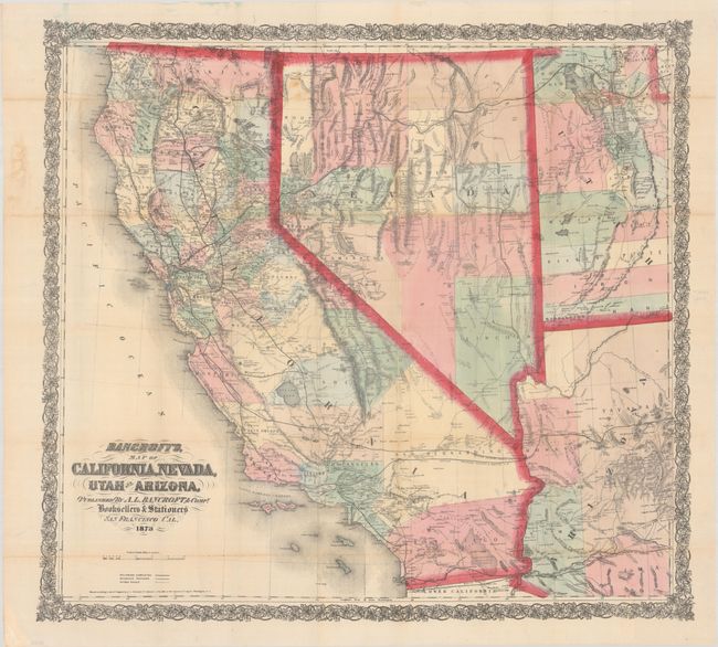
"Bancroft's, Map of California, Nevada, Utah and Arizona", Bancroft, A.L. & Company
Subject: Southwestern United States
Period: 1873 (dated)
Publication:
Color: Hand Color
Size:
32.8 x 30.2 inches
83.3 x 76.7 cm
Download High Resolution Image
(or just click on image to launch the Zoom viewer)
(or just click on image to launch the Zoom viewer)
This large pocket map was first published in 1864 by Bancroft, who Wheat describes as the "greatest map publisher of the Pacific Coast." It covers all of California and Nevada along with the western parts of Utah and Arizona extending to Salt Lake City and Prescott. There is remarkable detail, particularly in the mining regions, with a large number of camps and towns named. The map also depicts railroads, current and proposed, wagon roads, hundreds of towns, springs, forts, and more. Embellished by fancy, Victorian-style titling and a decorative wide border. Printed on fine banknote-style paper. A scarce and attractive map that is in remarkable condition.
References: cf. Wheat (TMW) #1093; cf. Wheat (Gold) #321.
Condition: B+
Full contemporary color, issued folding, and now flattened with very light soiling and archival repairs to some splits and tiny holes along the folds. A chip in the bottom left corner, far from map image, has been replaced with old paper.
Estimate: $1,100 - $1,400
Current High Bid:
$0
Reserve: Reserve Not Met
Next Bid: $550
Bid Increments
$500 - $999$50
$1,000 - $2,499$100
$2,500 - $4,999$250
$5,000 - $9,999$500
Terms & Conditions