Current Auction
"[Untitled - World]", Schouten, Willem Cornelisz
Subject: World
Period: 1618 (circa)
Publication: Journal Oste Beschrijvinghe van der Wonderlicke Reyse...
Color: Hand Color
Size:
8.9 x 6.1 inches
22.6 x 15.5 cm
Download High Resolution Image
(or just click on image to launch the Zoom viewer)
(or just click on image to launch the Zoom viewer)
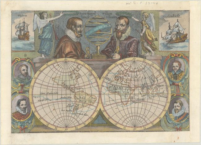
This map was issued in a small book chronicling Willem Schouten and Jacob Le Maire's voyage around the world from 1615-17. It was first published by Willem Blaeu, who Shirley notes may have commissioned the map. The double-hemisphere world map shows the voyage's tracks, including the discovery of a new strait off of Tierra del Fuego (named after Le Maire), and the continents in simple outline form. Surrounding the map are portraits of other circumnavigators including Francis Drake, Thomas Cavendish, Olivier van Noort and George van Spilbergen. Above the map are portraits of Ferdinand Magellan and Willem Schouten, each flanked by angels. In the top corners are depictions of the two ships used in the expedition - the Victoria and Eendracht. This map appears to be the first state, lacking the names of the tropics, Japan, and the Cape of Good Hope. However, Shirley notes several later editions dating to 1658, some of which are nearly identical to the first state, so the exact state and publication date is unknown.
See also lot 779 for Rodney Shirley's The Mapping of the World - Early Printed World Maps 1472-1700 that describes this map.
References: Shirley #297.
Condition: B+
Remargined on all sides with expert repairs to several separations along one vertical fold. Issued folding.
Estimate: $1,100 - $1,400
Current High Bid:
$550
Reserve: Reserve Not Met
Next Bid: $600
Bid Increments
$500 - $999$50
$1,000 - $2,499$100
$2,500 - $4,999$250
$5,000 - $9,999$500
Terms & Conditions