Current Auction
"Le Petrole dans le Monde"
Subject: World, Oil
Period: 1956 (dated)
Publication:
Color: Printed Color
Size:
45.3 x 37.1 inches
115.1 x 94.2 cm
Download High Resolution Image
(or just click on image to launch the Zoom viewer)
(or just click on image to launch the Zoom viewer)
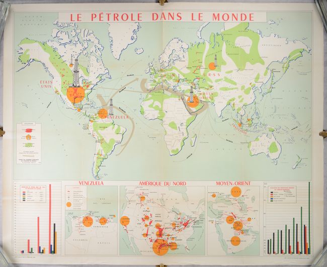
This wall-sized map depicts the global oil and gas industry, with particular focus on the key producing regions in Venezuela, the United States, and the Middle East. The yellow circles show the key regions that produce oil, with the size of the oil rig towers representing the amount of crude oil produced. The red areas are the operating oil fields while the green regions are sedimentary lands that are likely to contain petroleum. The gray arrows show the primary exportation routes throughout the world for petroleum products. Inset maps of Venezuela, the United States, and the Middle East at bottom locate current pipelines, pipeline projects, and refineries. The two graphs in the bottom corners show the change in oil production between 1900-54 in the key regions, as well as the evolution of the primary sources of energy (coal, oil, natural gas, and hydraulic power) worldwide during the same time period. Printed by Imp. Lafayette and published by the Union des Chambres Syndicales de l'Industrie du Petrole in Paris.
References:
Condition: A
Issued folding and now flattened and backed with tissue to reinforce and repair several short fold separations. There is some minor creasing confined to the bottom blank margin. The map has been stored rolled and does not currently lay flat on its own.
Estimate: $800 - $950
Current High Bid:
$0
Reserve: Reserve Not Met
Next Bid: $400
Bid Increments
$250 - $499$25
$500 - $999$50
$1,000 - $2,499$100
$2,500 - $4,999$250
Terms & Conditions