Current Auction
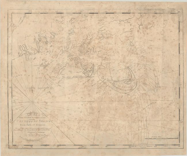
Title Sheet of John Norman's Rare Chart of the New England Coastline, Featuring Martha's Vineyard and Nantucket Island
"Chart from New York to Timber Island Including Nantucket Shoals from the Latest Surveys...", Norman, John
Subject: Southern Massachusetts, Martha's Vineyard & Nantucket Island
Period: 1791 (circa)
Publication: The American Pilot...
Color: Black & White
Size:
20.3 x 16.3 inches
51.6 x 41.4 cm
Download High Resolution Image
(or just click on image to launch the Zoom viewer)
(or just click on image to launch the Zoom viewer)
This is the south central title sheet of Norman's rare chart spanning the Atlantic coast from Manhattan to Maine. The chart was first published in 1791 in The American Pilot, only the second marine atlas published in America after Mathew Clark's A Complete Set of Charts of the Coast of America (1790). Norman reissued the atlas in 1792 and 1794, with his son William publishing five further editions between 1794 and 1803. After William's death in 1807, John took over for publication of new editions in 1810 and 1812. His successor Andrew Allen published the final edition in 1816. Despite the deep publishing history, the atlases and the charts therein are very rare on the market; counting all the editions, Boston Rare Maps notes only 20 copies of the atlas in institutional collections (at least 4 of which are incomplete) and is aware of only 3 possessed by private collectors.
In the first edition, Chart from New York to Timber Island... was comprised of six plates, arranged in a reversed "L" shape; the second state, published in 1794, adds a seventh sheet at right showing Plymouth Bay, giving the map a sort of inverted "T" shape. Later editions omit the top sheet showing Timber Island and Plymouth Bay sheet at right. This example likely comes from an early issue, before the plate was recut in 1803. It is printed on two sheets, joined (the second sheet is just the far eastern portion of the map). The title sheet covers from the Rhode Island-Massachusetts border to Chatham Old Har. Martha's Vineyard, Chappaquiddick, Nantucket, and the smaller nearby islands are all well-depicted. Dartmouth, New Bedford, Wareham, Sandwich, Barnstable, Harwich, Edgartown, and several other towns and cities are named. The most notable feature here is the navigational information, including depth soundings, anchorages, currents, hazards, shoals, and more, which would have been an invaluable tool for the commercial mariners working the New England coastline. In the title cartouche is a note of approval from Osgood Carleton, "Teacher of Navigation and Other Branches of the Mathematics": "I have carefully examined this chart and find it to agree with Hollands Surveys the Shoals by one well Authenticated by Brh Pilots."
References: McCorkle #791.4; Wheat & Brun #151.
Condition: C+
On a foxed and lightly soiled sheet with professional repairs replacing losses in the the lower border and margin and top right corner, and some small tears in the map image. The border at bottom (including the "dangerous" southern shoal) and a couple sections of the border at right, as well as the "he" in "From the latest Surveys" in the title cartouche, have been replaced in facsimile. There are a couple tiny wormholes that have not been infilled and a few small areas of image loss with no facsimile work.
Estimate: $2,750 - $3,500
Current High Bid:
$0
Reserve: Reserve Not Met
Next Bid: $1,400
Bid Increments
$1,000 - $2,499$100
$2,500 - $4,999$250
$5,000 - $9,999$500
$10,000 - $24,999$1,000
Terms & Conditions