Current Auction
"Carta Rappresentante il Porto di Boston", Gazzettiere Americano
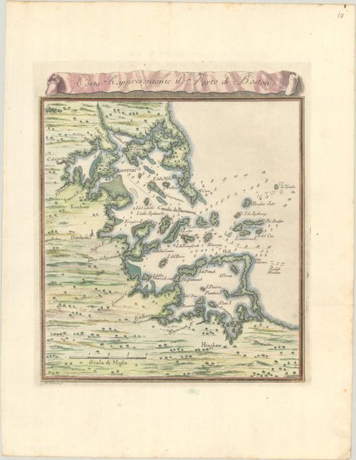
Subject: Boston Harbor, Massachusetts
Period: 1763 (circa)
Publication: Il Gazzettiere Americano
Color: Hand Color
Size:
7.1 x 8.3 inches
18 x 21.1 cm
Download High Resolution Image
(or just click on image to launch the Zoom viewer)
(or just click on image to launch the Zoom viewer)
This scarce Italian-produced map showing the vicinity of Boston Harbor is engraved in typical beautiful Italian style with dark, bold lines. Boston is in the northern third of the map that extends south to include Hingham. The map locates Roxbury, Dorchester, and Cambridge. Coastal towns, harbor features, and islands are well mapped and recognizable. Dozens of soundings and the main ship channel are clearly shown. The decorative script title is contained in a scroll banner that floats above the map. A most uncommon map that was issued between the French and Indian War and the American Revolutionary War. Engraved by Giuseppe Maria Terreni.
References:
Condition: A
A sharp impression with light foxing confined to the sheet's edges and a couple of printer's creases in the blank margins. The paper is lightly cockled.
Estimate: $230 - $275
Price: $170
Bid Increments
$100 - $249$10
$250 - $499$25
$500 - $999$50
$1,000 - $2,499$100
Terms & Conditions