Current Auction
Rare Map of the Subdivision of the “Holy Ground” of the Bunker Hill Battlefield
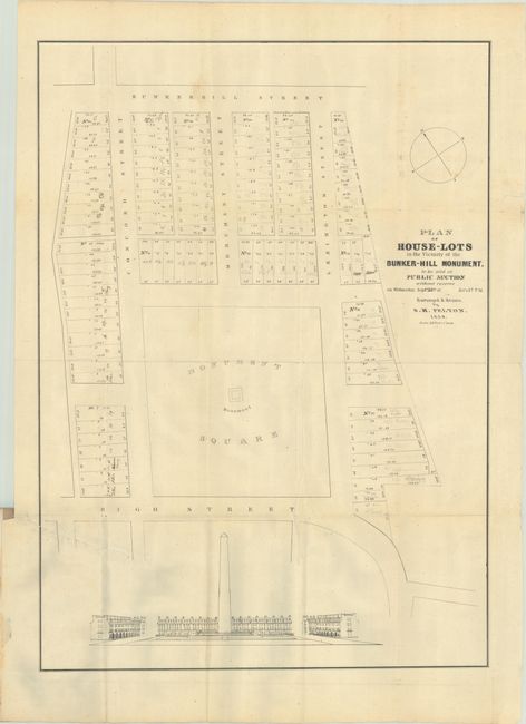
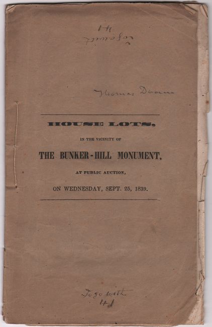
"[Map in Report] Plan of House-Lots in the Vicinity of Bunker-Hill Monument to be Sold at Public Auction... [in] Conditions of Sale of House Lots, in the Vicinity of the Bunker-Hill Monument..."
Subject: Boston, Massachusetts
Period: 1839 (published)
Publication:
Color: Black & White
Size:
20 x 27.9 inches
50.8 x 70.9 cm
Download High Resolution Image
(or just click on image to launch the Zoom viewer)
(or just click on image to launch the Zoom viewer)
The Battle of Bunker Hill was the first major engagement of the Revolutionary War. The Bunker Hill Monument Association was formed to preserve the battlefield by purchasing land from various owners and building a monument. Henry Dearborn, a Board Member, wrote: “If any spot in this country should be consecrated as holy ground …, that spot surely is Bunker Hill.” However, funding for the monument was a challenge, and the Association resorted to selling 10 acres of the battlefield. The auction netted $48,000, but most of the proceeds paid off the Association’s debt. The Monument later was completed in 1843 with funds raised by magazine editor Sarah J. Hale.
This map, surveyed and drawn by S.M. Felton, shows the subdivision plan surrounding ”Monument Park,” the only portion of “holy ground” preserved. A view at the bottom shows the proposed finished monument flanked by stately houses required by the restrictions of the sale. The map is also of historical significance as an early example of an American real estate subdivision plan. 8 pages. Original printed wrappers with string ties. We found no past sales listings for this map in 30 years and only 3 institutional listings on OCLC.
References:
Condition: B+
The folding map has a 5" binding tear at left that has been closed on verso with old tape and manuscript notations throughout. Text has scattered foxing and some pencil notations. Wrappers are intact with light wear and a couple of ink notations.
Estimate: $240 - $300
Price: $120
Bid Increments
$100 - $249$10
$250 - $499$25
$500 - $999$50
$1,000 - $2,499$100
Terms & Conditions