Current Auction
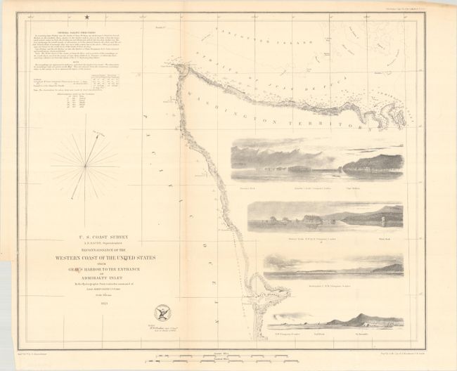
"Reconnaissance of the Western Coast of the United States from Gray's Harbor to the Entrance of Admiralty Inlet", U.S. Coast Survey
Subject: Western Washington
Period: 1853 (dated)
Publication:
Color: Black & White
Size:
17.7 x 14.7 inches
45 x 37.3 cm
Download High Resolution Image
(or just click on image to launch the Zoom viewer)
(or just click on image to launch the Zoom viewer)
The Office of Coast Survey is the oldest U.S. scientific organization, dating from 1807 when Congress directed that a "survey of the coast" be carried out. By 1836, it was called the U.S. Coast Survey and in 1878, the name was changed to the U.S. Coast and Geodetic Survey. Today the Office of Coast Survey is a division of the National Oceanic and Atmospheric Administration NOAA.
The survey teams, composed of civilians as well as Army and Naval officers, charted the nation's waterways and produced a wide array of reports, survey charts, hydrographic studies of tides and currents, astronomical studies and observations, and coastal pilots. These charts are an important record of the changing nature of the nation's coastlines. In additional to coastal charts, the U.S. Coast and Geodetic Survey produced land sketches, Civil War battle maps, and the early aeronautical charts.
This reconnaissance chart provides some early details to the entrance to the Straits of Juan de Fuca, the entrance to Puget Sound, and Gray's Harbor to the south. Illustrated by four profile views showing Cape Flattery, Destruction Island, Sail Rock and Pt. Grenville.
References:
Condition: B+
Issued folding with a hint of toning along the vertical fold and some minor creasing. A tiny binding tear at left has been closed on verso with archival tape.
Estimate: $90 - $110
Price: $65
Bid Increments
Under $50$1
$50 - $99$5
$100 - $249$10
$250 - $499$25
$500 - $999$50
Terms & Conditions