Current Auction
"Preliminary Geological Map of the Yellowstone National Park ", Hayden, Ferdinand Vandeveer
Subject: Yellowstone, Wyoming
Period: 1883 (published)
Publication: Twelfth Annual Report of the United States Geological and Geographical Survey
Color: Printed Color
Size:
28.6 x 32 inches
72.6 x 81.3 cm
Download High Resolution Image
(or just click on image to launch the Zoom viewer)
(or just click on image to launch the Zoom viewer)
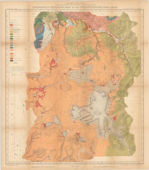
This map is one of two relating to Yellowstone (the other being topographical) that Wheat felt raised the cartography of Yellowstone to a "vastly higher level…and must be regarded as the first modern maps of the Park." It is a spectacular, early chromolithograph map of Yellowstone printed in 18 colors by the notable firm of Julius Bien. W.H. Holmes was the Geological Assistant to Hayden. Although 3 or 4 reports had been written previously about the park, Holmes felt that there was still much more ground to be covered and said that he could have spent years, instead of the just the summer of 1878, to properly explore the geology of the park's 3,400 square miles. The map is highly detailed on a scale of 1 inch = 2 miles and filled with contour lines at 100 feet increments. The color key at top left defines the geologic groups. The map was completed circa 1878 and published in Hayden's Twelfth Annual Report in 1883.
See also lot 784 for Carl Wheat's Mapping the Transmississippi West that describes this map.
References: Wheat (TMW) #1296.
Condition: B
Issued folding and now flat with archival repairs to a number of fold separations with minor loss at a few fold junctions. There is light toning along the fold lines.
Estimate: $275 - $350
Price: $200
Bid Increments
$100 - $249$10
$250 - $499$25
$500 - $999$50
$1,000 - $2,499$100
Terms & Conditions