Current Auction
"Carte Generale des Etats-Unis et du Mexique Comprenant l'Amerique Centrale et les Antilles", Andriveau-Goujon, E.
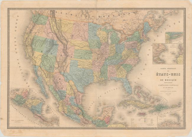
Subject: United States & Mexico
Period: 1868 (dated)
Publication:
Color: Hand Color
Size:
35.6 x 24.4 inches
90.4 x 62 cm
Download High Resolution Image
(or just click on image to launch the Zoom viewer)
(or just click on image to launch the Zoom viewer)
This large and beautifully engraved map is highly detailed and has attractive full pastel coloring. Most political boundaries in the West are correct, but Nevada is oddly shortened in the south with the entire lower portion going to California. Wyoming's western border is still oversized as it extends to the Continental Divide, and Oklahoma is the Indian Territory. The map details major wagon and emigrant roads, railroads, forts and much more. It extends to show all of Mexico, Guatemala and the Caribbean. Insets show the Lesser Antilles, Central America, the Atlantic Ocean, and the vicinity of Long Island. On four sheets joined, as issued.
References:
Condition: B+
Full contemporary color with some minor foxing and staining. The map has been skillfully rejoined along the horizontal fold with archival tape. There are a few pencil notations along the lower left border.
Estimate: $275 - $350
Current High Bid:
$0
Reserve: Reserve Not Met
Next Bid: $140
Bid Increments
$100 - $249$10
$250 - $499$25
$500 - $999$50
$1,000 - $2,499$100
Terms & Conditions