Current Auction
"Hispaniae Novae sive Magnae Vera Descriptio", Quad, Matthias von Kinckelbach
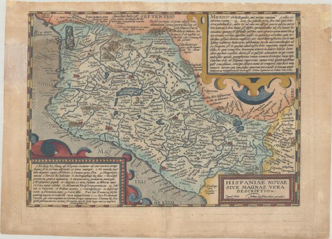
Subject: Western Mexico
Period: 1608 (circa)
Publication: Fasciculus Geographicus...
Color: Hand Color
Size:
11.5 x 8.2 inches
29.2 x 20.8 cm
Download High Resolution Image
(or just click on image to launch the Zoom viewer)
(or just click on image to launch the Zoom viewer)
This is a boldly engraved map of Mexico, based on the Ortelius map that became the prototype map of the region. It covers the Pacific coast from present-day Acapulco to about Mazatlan and inland to Mexico City, which is situated on a large lake. It is densely engraved with place names and shows the mining districts northwest of Mexico City. Two large cartouches contain Latin text describing the country and its history, while a smaller cartouche contains the title. Engraved by Johannes Bussemacher. Latin text on verso.
References: Mickwitz & Miekkavaara #240-84.
Condition: B
A nice impression on watermarked paper with some soiling and dampstaining that enters the map image at top and at left. Along the top edge there are short edge tears that have been repaired with archival materials on verso. There are a few small abrasions in the text at top right.
Estimate: $275 - $350
Current High Bid:
$0
Reserve: Reserve Not Met
Next Bid: $140
Bid Increments
$100 - $249$10
$250 - $499$25
$500 - $999$50
$1,000 - $2,499$100
Terms & Conditions