Current Auction
"[Lot of 2] A Map of the Isthmus of Darien, & Bay of Panama [on sheet with] The North Sea Coast of the Isthmus of America... [and] The South Sea Coast of the Isthmus of America... [and] A Map of the Isthmus of Panama..."
Subject: Panama
Period: 1699-1783 (circa)
Publication:
Color:
Size:
See Description
Download High Resolution Image
(or just click on image to launch the Zoom viewer)
(or just click on image to launch the Zoom viewer)
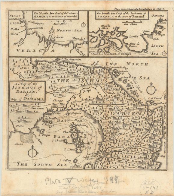
A. A Map of the Isthmus of Darien, & Bay of Panama [on sheet with] The North Sea Coast of the Isthmus of America to the West of Portobel [and] The South Sea Coast of the Isthmus of America to the West of Panama, by Lionel Wafer, from A New Voyage Round the World..., circa 1697, black & white (6.3 x 6.3"). This unusual sheet features three small maps illustrating William Dampier's travels around Central America during his first circumnavigation voyage in the 1680s. The largest of the maps depicts the Isthmus and Bay of Panama. Dampier participated in raids on Spanish ships in this region with Captain Bartholomew Sharp, an English buccaneer. The small map at top left depicts the stretch of coastline from Nicaragua to Portobelo. At top right, another small map depicts the southern coast of Panama from Quibo, or Quicaro, or Cobaya (Coiba Island) and nearby islands east to Panama City. Unmistakably engraved by Herman Moll in his charming and distinctive style. Reference: Shirley (BL Atlases) G.DAM-1a #2. Condition: A nice impression on a watermarked sheet with light foxing and toning along the fold. (B+)
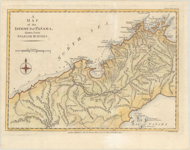
B. A Map of the Isthmus of Panama, Drawn from Spanish Surveys, by John Lodge, from Political Magazine, dated 1783, hand color (9.5 x 6.7"). This fine small map from the March 1783 issue of Political Magazine covers a section of the Isthmus of Panama. It is very similar to the Jefferys map of the same title, published 20 years earlier, albeit smaller in size. The map features excellent topographical detail, rivers, towns and cities (including Panama City, Portobelo, and Chagres), ruins, and roads. Soundings, hazards, and anchorages are shown in the surrounding waters. Published by J. Bew. References: Jolly #POL-70; Kapp (MCC-73) #86. Condition: Issued folding, now flat, with minor offsetting. (A)
References:
Condition:
See description above.
Estimate: $140 - $170
Current High Bid:
$150
Reserve: Reserve Met
Next Bid: $160
Bid Increments
$100 - $249$10
$250 - $499$25
$500 - $999$50
$1,000 - $2,499$100
Terms & Conditions