Current Auction
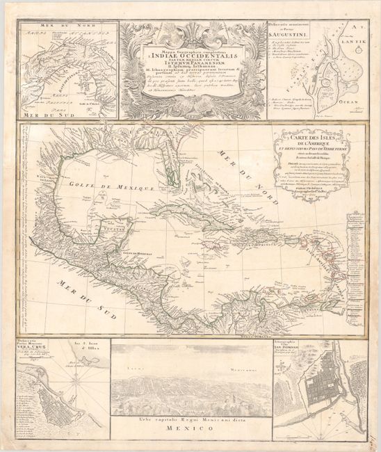
"Mappa Geographica, Complectens I. Indiae Occidentalis Partem Mediam Circum Isthmum Panamensem II. Ipsumq Isthmum. III. Ichnographiam Praecipuorum Locorum & Portuum ad has Terras Pertinentium...", Homann Heirs
Subject: Gulf of Mexico & Caribbean
Period: 1740 (dated)
Publication:
Color: Hand Color
Size:
19.3 x 23 inches
49 x 58.4 cm
Download High Resolution Image
(or just click on image to launch the Zoom viewer)
(or just click on image to launch the Zoom viewer)
This informative and very graphic folio sheet has a large map of the region, titled Carte des Isles de l'Amerique et Deplusieurs Pays de Terre Ferme, attributed to D'Anville (1731). The map covers the Gulf of Mexico, Central America, and all of the Caribbean islands. It is nicely detailed with a key to show European possessions and a beautifully engraved title cartouche. Above the main map is the large, decorative title cartouche, flanked by insets of the isthmus of Panama and a plan of St. Augustine in Florida. Below the map is a large view of Mexico City, flanked by plans of Vera Cruz and San Domingo. A very handsome sheet, absolutely filled with information on the West Indies.
References:
Condition: B+
Contemporary outline color on a bright sheet with a spearhead watermark and light soiling. A chip that enters about 3/4" into the inset at top left has been professionally repaired with the image skillfully replaced in facsimile.
Estimate: $500 - $650
Current High Bid:
$250
Reserve: Reserve Not Met
Next Bid: $275
Bid Increments
$250 - $499$25
$500 - $999$50
$1,000 - $2,499$100
$2,500 - $4,999$250
Terms & Conditions