Current Auction
Jefferys Fine Map of the Virgin Islands - Corrected and Improved
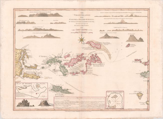
"The Virgin Islands from English and Danish Surveys", Jefferys/Laurie & Whittle
Subject: Virgin Islands
Period: 1797 (dated)
Publication: The West Indian Atlas...
Color: Hand Color
Size:
24.1 x 18.3 inches
61.2 x 46.5 cm
Download High Resolution Image
(or just click on image to launch the Zoom viewer)
(or just click on image to launch the Zoom viewer)
Thomas Jefferys was one of the most important English map publishers of the 18th century. His work included prints and maps of locations around the world, but his most notable maps are of North America and the West Indies. He began his career in the map trade in the early 1730s, working as an engraver for a variety of London publishers, and eventually setting up his own shop. In 1746, he was appointed Geographer to the Prince of Wales, and in 1760 he became Geographer to the King. These titles granted access to manuscripts and cartographic information held by the government. In the early 1760s he embarked on an ambitious project to produce a series of English county maps based on new surveys, but ran out of money and filed for bankruptcy in 1766. He then partnered with London publisher Robert Sayer, who reissued many of Jefferys plates and continued to issue new editions after Jefferys' death in 1771. Jefferys' American Atlas and the accompanying West-India Atlas, published post posthumously, are considered his most important cartographic works.
This finely engraved map of the Virgin Islands depicts the English and Danish possessions surrounding St. Francis Drake's Bay. It also covers the eastern part of Puerto Rico, Anguilla, Saint Christopher, Saint Martin, Saba and St. Eustatius. The map illustrates anchorages, soundings, shoals, channels through the islands, and the administrative divisions of St. Croix. Relief is shown pictorially and there are several notations throughout. Also featured on the sheet are 12 profile views of the islands at top, 2 inset maps, and a historical and geographical note at bottom. The map was first executed by Jefferys and corrected and improved here by the surveys of Captain James Waring. Published by Laurie & Whittle at No. 53 Fleet Street.
References: cf. Sellers and Van Ee #1982; cf. Shirley (BL Atlases) M.JEF-4a #26.
Condition: A
A crisp impression on paper with a Strasbourg Lily watermark that has been backed with tissue to repair a centerfold separation in the bottom blank margin. There are a few faint spots and tiny wormholes only visible when held to light. Light staining is confined to the far blank margins and there are a few small chips in the bottom right sheet corner.
Estimate: $1,600 - $1,900
Current High Bid:
$0
Reserve: Reserve Not Met
Next Bid: $800
Bid Increments
$500 - $999$50
$1,000 - $2,499$100
$2,500 - $4,999$250
$5,000 - $9,999$500
Terms & Conditions