Current Auction
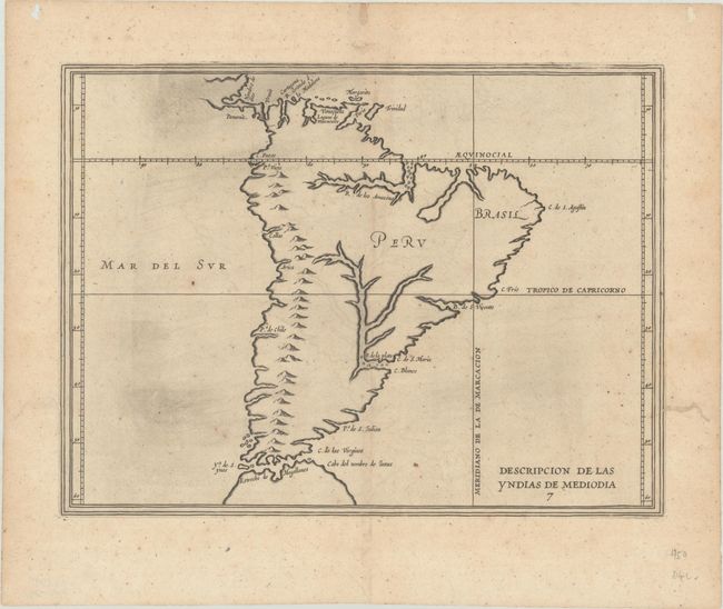
"Descripcion de las Yndias de Mediodia ", Herrera y Tordesillas, Antonio de
Subject: South America
Period: 1622 (circa)
Publication: Descripcion de las Indias Occidentalis
Color: Black & White
Size:
11.4 x 8.6 inches
29 x 21.8 cm
Download High Resolution Image
(or just click on image to launch the Zoom viewer)
(or just click on image to launch the Zoom viewer)
Antonio de Herrera Y Tordelisllas was the official historian of Spain and the Indies. He compiled a history of the Spanish conquests and early explorations in the Americas, which included this simply engraved map of the continent. His work (Historia General de los Hechos de los Castellanos) was originally published in 1601 with several editions and translations thereafter, all of which are scarce. The map itself is largely derived from the manuscript charts of Juan Lopez de Velasco. Cartographically, the continent is dominated by the huge R. de los Amazona and R. de la Plato and the western mountain range. The Papal Line of Demarcation (Meridiano de la de Marcacion), which divided the non-Christian world between Spain and Portugal, divides the continent between Portugal’s tiny Brazil with the rest (Peru) belonging to Spain.
References: Shirley (BL Atlases) G.HERR-2a #8.
Condition: A
A dark impression on a watermarked sheet with light printer's ink residue, a hint of offsetting, one unrepaired worm hole at top left, and several worm tracks in the blank margins that have been professionally repaired, one of which touches the neatline at right.
Estimate: $475 - $600
Current High Bid:
$250
Reserve: Reserve Not Met
Next Bid: $275
Bid Increments
$250 - $499$25
$500 - $999$50
$1,000 - $2,499$100
$2,500 - $4,999$250
Terms & Conditions