Current Auction
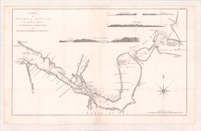
"Carte du Detroit de Magellan dans Laquelle on a Insere les Observations et les Decouvertes du Capne. Byron, du Capne. Wallis, et du Capne. Carteret", Benard, Jacques Francois
Subject: Strait of Magellan
Period: 1780 (circa)
Publication: Relation des Voyages Entrepris par Ordre de sa Majeste Britannique...
Color: Black & White
Size:
29.9 x 18.3 inches
75.9 x 46.5 cm
Download High Resolution Image
(or just click on image to launch the Zoom viewer)
(or just click on image to launch the Zoom viewer)
A spectacular chart detailing the Straits of Magellan and illuminating the truly complicated and treacherous nature of this passage. It depicts the discoveries of the navigators Byron, Wallis, and Carteret. Terrific detail includes soundings, current directions, rocks, and anchorages. Four large land approach views (Cap des Vierges, Rochers Blancs, Cap Beau Tems, and Vue du Port Famine) in upper third show the land to be rugged and mountainous. Published in a French edition of John Hawkesworth's An Account of the Voyages Undertaken by the Order of his Present Majesty for Making Discoveries in the Southern Hemisphere.
References:
Condition: B+
Issued folding and now flattened and backed with tissue to repair a 2.5" tear at upper center and a few short fold separations. There is foxing mostly at lower center and some faint offsetting.
Estimate: $160 - $190
Price: $120
Bid Increments
$50 - $99$5
$100 - $249$10
$250 - $499$25
$500 - $999$50
Terms & Conditions