Current Auction
"Peace Map of Europe Following Demands of President Wilson - The Rand McNally New Libraty Atlas Map of Europe", Rand McNally & Co.
Subject: Europe, World War I
Period: 1918 (circa)
Publication:
Color: Printed Color
Size:
25.9 x 18.8 inches
65.8 x 47.8 cm
Download High Resolution Image
(or just click on image to launch the Zoom viewer)
(or just click on image to launch the Zoom viewer)
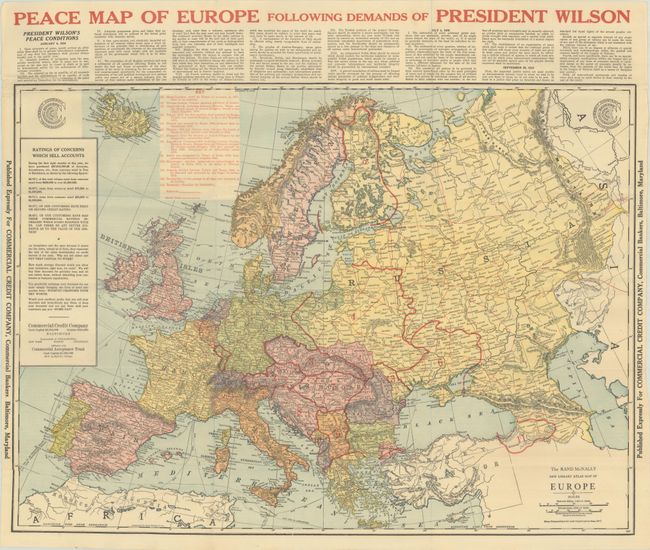
This map of Europe was published at the end of World War I by the Commercial Credit Company in Baltimore, Maryland. It prominently shows the continent's new political boundaries in red overprinting as a result of the fall of the Russian and Austro-Hungarian empires. There were a total of 13 boundary changes including the creation of Finland, Poland, Ukraine, Czechoslovakia. Above the map is Woodrow Wilson's 14-point program for peace negotiations, most notably the creation of the League of Nations (#14). Blank verso.
For an interesting article on how Rand McNally & Co. contributed to war efforts, click here.
References: Rumsey #14076.
Condition: A
Issued folding on a clean sheet with a few tiny splits at the fold junctions and some minor creasing at lower left.
Estimate: $140 - $170
Current High Bid:
$70
Reserve: Reserve Not Met
Next Bid: $75
Bid Increments
$50 - $99$5
$100 - $249$10
$250 - $499$25
$500 - $999$50
Terms & Conditions