Current Auction
"Veteris et Novae Britanniae Descriptio", Cluver, Philipp
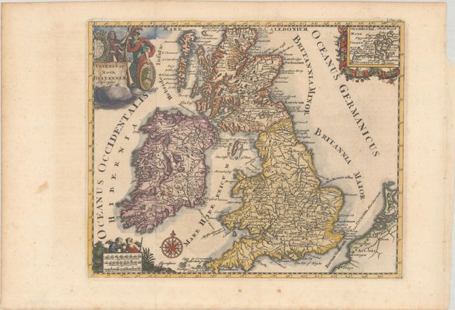
Subject: Britain
Period: 1729 (published)
Publication: Introductionis in Universam Geographiam
Color: Hand Color
Size:
10.3 x 8.4 inches
26.2 x 21.3 cm
Download High Resolution Image
(or just click on image to launch the Zoom viewer)
(or just click on image to launch the Zoom viewer)
Very decorative small map of Britain showing counties and major cities. A decorative inset at upper right depicts the Orkney Islands. Embellished with a compass rose, distance scale with two angels, and a title cartouche featuring the royal coat of arms and a soldier.
Cluver's Introductio in Universam Geographicam was a popular atlas, appearing in over 45 editions during a 100-year period. The first edition was published without maps in the 1620s, and the first edition to include maps was published circa 1641. The various editions were published in different cities throughout Europe, including Amsterdam, Nuremberg, and London, often with new sets of maps engraved. This map is from an edition published in Amsterdam by Joannem Pauli with maps by Jan Wolters.
References: Shirley (BL Atlases) T.CLUV-8b.
Condition: A
A dark impression, issued folding on a sheet with a hint of offsetting and a few spots in the blank margins.
Estimate: $140 - $170
Current High Bid:
$70
Reserve: Reserve Not Met
Next Bid: $75
Bid Increments
$50 - $99$5
$100 - $249$10
$250 - $499$25
$500 - $999$50
Terms & Conditions