Current Auction
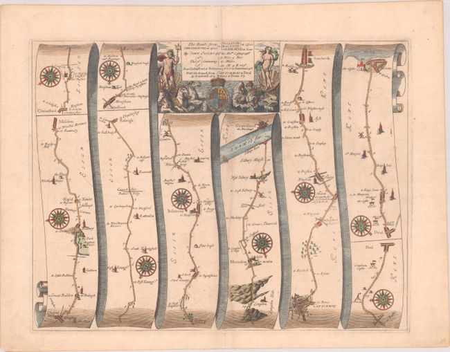
"The Roads from Chelmsford in Essex to Maldon, Raleigh in Essex Gravesend in Kent", Ogilby, John
Subject: Southeastern England
Period: 1675 (circa)
Publication: Britannia
Color: Hand Color
Size:
16.8 x 12.9 inches
42.7 x 32.8 cm
Download High Resolution Image
(or just click on image to launch the Zoom viewer)
(or just click on image to launch the Zoom viewer)
John Ogilby's 'Britannia' was published between 1675 and 1698. It is a landmark in the mapping of England and Wales. Its unique format constituted the first national road-atlas of any country in Western Europe. It was composed of maps of seventy-three major roads and cross-roads, presented in a continuous strip-form, on a uniform scale of one inch to a mile. Each beautiful map includes wonderful detail of the countryside with each strip containing a large compass rose to indicate changes in direction.
This very nice road map is in the pictorial style pioneered by Ogilby, with the road from Chelmsford to Gravesend on the Thames laid out in several ribbon-like panels. The last two panels detail the side branch from Canterbury to Dover. Filled with details, the map includes villages, bridges, castles, windmills, and river crossings. This fine sheet is decorated with numerous compass roses and a boldly engraved title cartouche featuring the royal coat-of-arms flanked with mythological figures including Neptune on a chariot pulled by three hippocampi.
References: Moorland & Bannister, pp. 157-8; Shirley (BL Atlases) T.OGIL-4a #93.
Condition: A
A crisp impression on paper with a bunch of grapes watermark, a few minor spots, and a hint of offsetting along the centerfold.
Estimate: $400 - $475
Current High Bid:
$0
Reserve: Reserve Not Met
Next Bid: $200
Bid Increments
$100 - $249$10
$250 - $499$25
$500 - $999$50
$1,000 - $2,499$100
Terms & Conditions