Current Auction
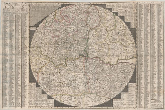
"A New & Correct Map of Thirty Miles Round London Shewing All the Towns, Villages Roads &c...", Overton, Henry
Subject: London, England
Period: 1720 (circa)
Publication:
Color: Hand Color
Size:
37.4 x 24.9 inches
95 x 63.2 cm
Download High Resolution Image
(or just click on image to launch the Zoom viewer)
(or just click on image to launch the Zoom viewer)
A scarce circular map of the environs of London extending from Okingham east to Rochester and from Baldock south to East Grinsted. It shows remarkable detail of villages and towns, cities in plan view, hundreds, postal roads, rivers, and more. Concentric circles radiate out from St. Paul's Cathedral at 5 mile intervals. Flanked by three tables of distances, a table of locks and bridges on the Thames River, and an extensive index at left and right. According to Howgego, this is the first state of the map, which appears to be based upon an earlier work by Charles Price (1712). Printed and sold by Henry Overton at the White Hors without Newgate.
References: Howgego #67.
Condition: B
A crisp impression on a sheet that has been backed with tissue to repair numerous fold separations, including professionally reattaching the right 6" (essentially the table).
Estimate: $900 - $1,100
Current High Bid:
$0
Reserve: Reserve Not Met
Next Bid: $450
Bid Increments
$250 - $499$25
$500 - $999$50
$1,000 - $2,499$100
$2,500 - $4,999$250
Terms & Conditions