Current Auction
"Orbis Terrarum Tabula Recens Emendata et in Lucem Edita", Stoopendaal, Daniel
Subject: World
Period: 1714 (circa)
Publication:
Color: Hand Color
Size:
18 x 13.9 inches
45.7 x 35.3 cm
Download High Resolution Image
(or just click on image to launch the Zoom viewer)
(or just click on image to launch the Zoom viewer)
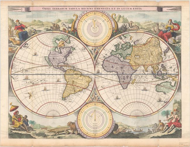
This decorative double hemisphere world map was issued in a Dutch Bible published by the Keur family. It is based on Visscher's Bible map of 1663 and is surrounded by nearly identical engravings, which include numerous exotic animals and four female allegorical representations of the continents. California is depicted as an island with a flat northern coastline labeled Nova Albion. A small island in the vicinity of Alaska is labeled Anian. In Asia, the Great Wall of China is illustrated and the northeastern coastline is severely truncated. Australia, Van Diemens Landt, and New Zealand have incomplete coastlines. New Guinea looks as if it may be attached to Australia. Tucked between the cusps of the map are astronomical diagrams illustrating the Copernican and Ptolemaic solar system theories. This is the third state, with the imprint of Pieter and Jacob Keur added at bottom center. Dutch text on verso.
See also lot 779 for Rodney Shirley's The Mapping of the World - Early Printed World Maps 1472-1700 that describes this map.
References: Shirley #498; Poortman & Augusteijn #130 GII-3.
Condition: A
A crisp impression, issued folding. There is light toning, some small chips, and short tears contained within the top and bottom edges of the sheet, not affecting the image.
Estimate: $1,500 - $1,800
Current High Bid:
$1,100
Reserve: Reserve Met
Next Bid: $1,200
Bid Increments
$1,000 - $2,499$100
$2,500 - $4,999$250
$5,000 - $9,999$500
$10,000 - $24,999$1,000
Terms & Conditions