Current Auction
"Nouvelle Carte de l'Irlande, ou on Remarque l'Etat Present de Cette Isle, l'Ordre du Gouvernement Ecclesiastique et Politique, les Provinces, les Villes, et les Bourgs qui ont Droit de Deputer au Parlement", Chatelain, Henry Abraham
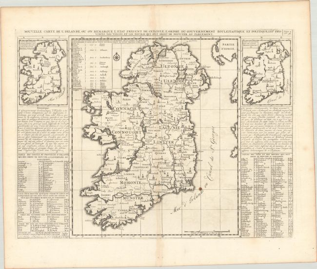
Subject: Ireland
Period: 1708 (circa)
Publication: Atlas Historique, Tome II
Color: Black & White
Size:
18.1 x 13.6 inches
46 x 34.5 cm
Download High Resolution Image
(or just click on image to launch the Zoom viewer)
(or just click on image to launch the Zoom viewer)
Handsome map of Ireland flanked with two smaller maps of the country showing changes from the ancient system of ecclesiastic divisions and how it was divided at the time of this map's creation. Detailed tables and panels of text surround the map with extensive information on the ancient towns, cities, lakes, rivers, and the governance of Ireland.
References: Koeman, Cha 4 #7.
Condition: B+
A crisp impression on a sheet with a Strasbourg Bend & Lily watermark. There is light toning along the centerfold, one small rust spot, and a tiny hole near West Meath only visible when held to light. A pair of wormholes are confined to the bottom blank margin.
Estimate: $140 - $170
Current High Bid:
$0
Reserve: Reserve Not Met
Next Bid: $70
Bid Increments
$50 - $99$5
$100 - $249$10
$250 - $499$25
$500 - $999$50
Terms & Conditions