Current Auction
Ortelius' Influential Map of the New World - Second Plate
"Americae sive Novi Orbis, Nova Descriptio", Ortelius, Abraham
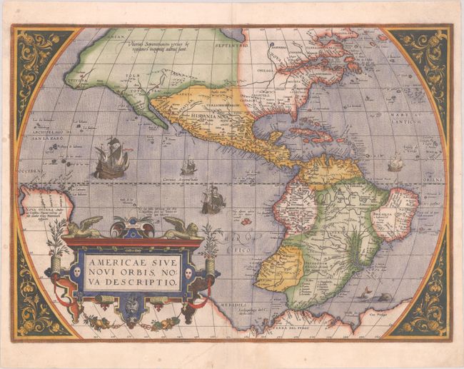
Subject: Western Hemisphere - America
Period: 1584 (published)
Publication: Theatrum Orbis Terrarum
Color: Hand Color
Size:
19.6 x 14.1 inches
49.8 x 35.8 cm
Download High Resolution Image
(or just click on image to launch the Zoom viewer)
(or just click on image to launch the Zoom viewer)
This is one of the most famous maps of America, and one that had enormous influence on the future cartography of the New World. The map is primarily based on Gerard Mercator's great multi-sheet world map of 1569. The most recognizable features of the map are the bulbous Chilean coastline and the exaggerated breadth of the North American continent. North America shows a lengthy St. Lawrence River reaching across the continent to nearly meet the fictitious, westward flowing Tiguas Rio. The strategically placed title cartouche hides the unknown South Pacific and therefore most of the conjectural great southern continent, which is shown attached to both New Guinea and Tierra del Fuego.
This map is from the second copper plate that contains identical geography to the first plate [1570]. In this plate the largest ship in the Pacific is now sailing east and away from the viewer. Due to religious persecution Ortelius had been forced to leave Antwerp and as a result there was a four year lapse in the publication of the Theatrum. When he reestablished himself in Liege he used the great printing house of Christopher Plantin to resume publication with a number of revised plates. This plate had a relatively short life of only 8 years, being replaced in 1587 with the plate easily distinguished from the revised shape of South America. Latin text on verso.
See also lot 783 for John Goss' The Mapping of North America - Three Centuries of Map-Making 1500-1860 that describes this map.
References: Burden #52; Goss (NA) #11; Van den Broecke #10.
Condition: B+
A crisp impression on a bright sheet with the coat of arms watermark of Claude Denise and a few small spots. A chip at bottom center that enters 1" high by 0.5" wide into the image has been professionally repaired with the image skillfully replaced in facsimile.
Estimate: $4,750 - $6,000
Current High Bid:
$0
Reserve: Reserve Not Met
Next Bid: $2,400
Bid Increments
$1,000 - $2,499$100
$2,500 - $4,999$250
$5,000 - $9,999$500
$10,000 - $24,999$1,000
Terms & Conditions