Current Auction
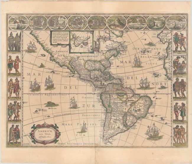
Blaeu's Stunning Carte-a-Figures Map of the Americas in Full Contemporary Color
"Americae Nova Tabula", Blaeu, Willem
Subject: Western Hemisphere - America
Period: 1638 (published)
Publication: Theatre du Monde ou Nouvel Atlas
Color: Hand Color
Size:
21.9 x 16.3 inches
55.6 x 41.4 cm
Download High Resolution Image
(or just click on image to launch the Zoom viewer)
(or just click on image to launch the Zoom viewer)
This stunning carte-a-figures map is a superb example of the fine art of decorative cartography and a seventeenth-century European view of the New World. The coastal outlines generally follow Ortelius and Wytfliet with nomenclature from a variety of explorers and colonists. Panels at sides, each with five portraits of the native inhabitants, were taken from John White (Virginia), Hans Staden (Brazil) and other early explorer's accounts. Across the top are nine town plans including Havana, St. Domingo, Cartegena, Mexico City, Cusco, Potosi, I. la Mocha in Chile, Rio de Janeiro and Olinda in Brazil. This is one of the few maps of the Americas by this famous Dutch cartographer. The map itself is similar to Blaeu's wall map of 1608 with the additional discoveries by Henry Hudson in North America, and Tierra del Fuego with Le Maire Strait. This is the third state of the plate with the imprint changed to Auct: Guiljelmo Blaeuw. French text on verso.
References: Burden #189; Goss (Blaeu) p. 156; Tooley (Amer) p. 297; Van der Krogt (Vol. II) #9000:2.
Condition: B+
A nice impression with full contemporary color on a sheet with very light toning, a bit of printer's ink residue, and a few small spots. There are archival repairs along the centerfold at bottom, just entering the map border.
Estimate: $4,000 - $4,750
Current High Bid:
$0
Reserve: Reserve Not Met
Next Bid: $2,000
Bid Increments
$1,000 - $2,499$100
$2,500 - $4,999$250
$5,000 - $9,999$500
$10,000 - $24,999$1,000
Terms & Conditions