Current Auction
Unique English Map with Island of California, Seven Cities of Cibola, and Proto-Alaska Northwest Coastline
"America", Heylin, Peter
Subject: Western Hemisphere - America
Period: 1703 (circa)
Publication: Cosmography in Four Books…
Color: Hand Color
Size:
16.7 x 14.1 inches
42.4 x 35.8 cm
Download High Resolution Image
(or just click on image to launch the Zoom viewer)
(or just click on image to launch the Zoom viewer)
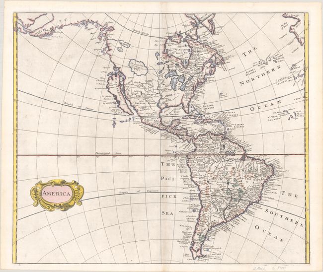
This rare and unusual map of the Americas features the island of California on the Sanson model. The western coastline stretches far to the northwest with several inventive place names, such as Desolation and Zapozipin, and imaginary islands along the coastline. This remarkable coastline looks very much like the early depictions of Alaska after the Russian and Cook explorations in the latter part of the eighteenth century. In the West are three spurious lakes: L. Aquinanbock, L. of Isles, and a huge lake labeled The Great Lake of Thongo or Thoya. These lakes all show possible rivers flowing from them into the Pacific denoted as dotted lines. The 7 Citites [of Cibola] are noted in New Grenada. The mythical Parime Lake is prominently shown in South America, where there is a surprising amount of detail and numerous place names. This map may have been designed by Robert Morden as there was an advertisement for the 1703 edition of Heylin's Cosmography stating that the new maps were to be by Morden. It is unique in its depiction of North America except for John Senex's map of 1719, which was apparently copied from it.
See also lot 786 for Glen McLaughlin's The Mapping of California as an Island that describes this map.
References: McLaughlin #154; The Map Collector #57, pp. 2-8.
Condition: A
A crisp impression on a sheet with a "B" watermark. There is a hint of toning along the centerfold.
Estimate: $700 - $850
Current High Bid:
$350
Reserve: Reserve Not Met
Next Bid: $375
Bid Increments
$250 - $499$25
$500 - $999$50
$1,000 - $2,499$100
$2,500 - $4,999$250
Terms & Conditions