Current Auction
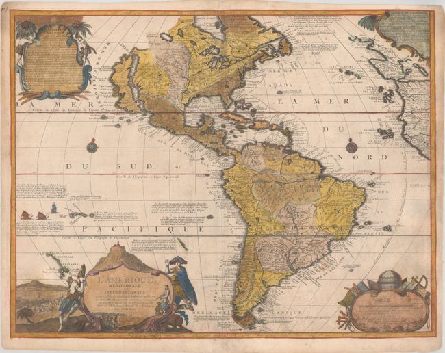
"L'Amerique, Meridionale, et Septentrionale. Dressee Selon les Dernieres Relations et Suivant les Nouvelles Decouvertes dont les Points Principaux sont Placez sur les Observations de Mrs. de l'Academie Royale des Sciences", Benard/De Fer
Subject: Western Hemisphere - America
Period: 1726 (dated)
Publication:
Color: Hand Color
Size:
23.8 x 18.3 inches
60.5 x 46.5 cm
Download High Resolution Image
(or just click on image to launch the Zoom viewer)
(or just click on image to launch the Zoom viewer)
This is de Fer's reduced version of his wall map of America. It features the Island of California covering the entire west coast north of the Tropic of Cancer. One of the prominent features in northern Mexico is Les Mine de S. Iean et de Ste. Barbe, the legendary Santa Barbara mines of the Chihuahua-Durango region. The Pacific Northwest and Alaska are essentially blank. There are also several large, spurious lakes on both continents, including Lake May in the Carolinas. A partial coastline of New Zealand appears beside the title cartouche. The map is richly decorated with four cartouches and two compass roses. Engraved by Hendrick van Loon, who also contributed to de Fer's wall map. This is the fifth state, dated 1726 with the imprint of De Fer's son-in-law, Jacques-Francois Bernard, at bottom right. Information on the history and divisions of the Americas was added to the cartouches in the top corners of the map in this state.
References: Burden #753.
Condition: B
A nice impression with bold, old color and moderate soiling. A 1" tear in Costa Rica and a 1.5" tear west of Chile have been archivally repaired. The map has been trimmed to the neatlines and pasted onto a folio sheet of period-correct paper.
Estimate: $800 - $950
Current High Bid:
$425
Reserve: Reserve Not Met
Next Bid: $450
Bid Increments
$250 - $499$25
$500 - $999$50
$1,000 - $2,499$100
$2,500 - $4,999$250
Terms & Conditions