Current Auction
"Americae Mappa Generalis Secundum Legitimas Projectionis Stereographicae Regulas Relationesque Recentissimas et Observationes...", Haas/Homann Heirs
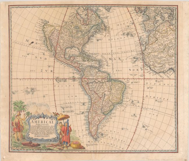
Subject: Western Hemisphere - America
Period: 1746 (dated)
Publication:
Color: Hand Color
Size:
20.6 x 18.1 inches
52.3 x 46 cm
Download High Resolution Image
(or just click on image to launch the Zoom viewer)
(or just click on image to launch the Zoom viewer)
This is a handsome, decorative eighteenth century map of the Americas with considerable detail throughout. It extends to the western part of Africa and southwest Europe. There is only an amorphous coastline shown above the peninsular California, with the Pacific Northwest left blank. The very large title cartouche includes two erupting volcanoes, Native Americans, palm trees, sugar cane, parrots, and a pot of gold. Johann Matthias Haas was a professor of mathematics at Wittenberg, and he worked with the Homann Heirs updating their map stock.
References:
Condition: B+
A nice impression with contemporary color in the map and later color in the cartouche on a sheet with a small coat of arms watermark. There is light soiling, a few ink stains in the Pacific Ocean, and some extraneous creasing at bottom right. There is a faint dampstain along the right edge of the sheet, entering the map image at bottom right.
Estimate: $400 - $475
Current High Bid:
$210
Reserve: Reserve Not Met
Next Bid: $220
Bid Increments
$100 - $249$10
$250 - $499$25
$500 - $999$50
$1,000 - $2,499$100
Terms & Conditions