Current Auction
Signed by Chase
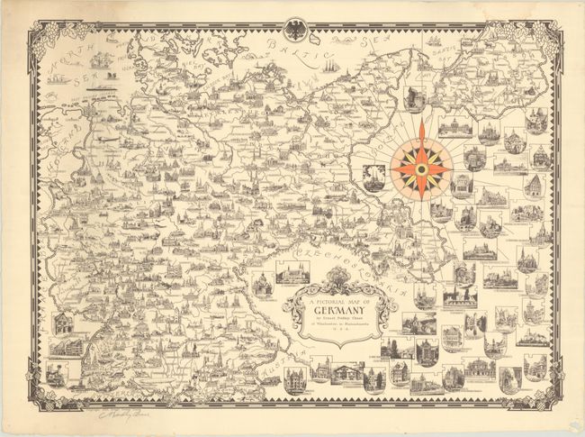
"A Pictorial Map of Germany", Dudley Chase, Ernest
Subject: Germany
Period: 1935 (dated)
Publication:
Color: Printed Color
Size:
23.4 x 17 inches
59.4 x 43.2 cm
Download High Resolution Image
(or just click on image to launch the Zoom viewer)
(or just click on image to launch the Zoom viewer)
This pictorial map of Nazi Germany is one of the earliest works by Ernest Dudley Chase (1878-1966), one of the leading figures in pictorial mapmaking during the middle 20th century. The map depicts Germany extending into Pomerania, Silesia, and East Prussia. Towns and cities are accompanied with miniature illustrations of buildings of note, with additional architectural vignettes filling the surrounding countries. We have identified six versions of this map - some in color, others in black & white, and some showing a Nazi swastika in the top border. This edition, with grapevine border and Federal Eagle at top, suggests a post-war publication date. Signed in pencil by Chase in the bottom left corner.
References: Hornsby (Picturing America) pp. 31-34; Rumsey #10731.
Condition: A
There is minor soiling at top left and a faint dampstain that just touches the border at top right. Pinholes and a small chip at bottom right are all confined to the margins.
Estimate: $240 - $300
Price: $180
Bid Increments
$100 - $249$10
$250 - $499$25
$500 - $999$50
$1,000 - $2,499$100
Terms & Conditions