Current Auction
"Rendsburgum, Chilonium et Bordesholma, sive Holsatia Propria", Blaeu, Johannes
Subject: Northern Germany
Period: 1659 (circa)
Publication:
Color: Hand Color
Size:
24.8 x 16.4 inches
63 x 41.7 cm
Download High Resolution Image
(or just click on image to launch the Zoom viewer)
(or just click on image to launch the Zoom viewer)
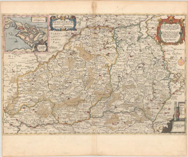
This map focuses on the region between Rendsburg and Neumunster and is filled with early roads, tiny towns, and political boundaries. The map extends west to Albersdorf and Wilster and east to Kiel and Ploen. The inset at top left gives a bird's eye plan of the fortified city and castle of Rendsburg. The map is adorned with two strapwork cartouches and a vertical distance scale that is supported by a surveyor with measuring dividers. The map is attributed to Johannes Mejer. Spanish text on verso, published between 1659-72.
References: Van der Krogt (Vol. II) #1665:2.2.
Condition: B+
A sharp impression with full contemporary color on a bright sheet with a large watermark of the god Atlas. There is staining along the centerfold at top, a worm track along the centerfold and minor soiling. Timmed at the sides by the bookbinder with loss of a portion of the neatline at left.
Estimate: $160 - $190
Price: $120
Bid Increments
$100 - $249$10
$250 - $499$25
$500 - $999$50
$1,000 - $2,499$100
Terms & Conditions