Current Auction
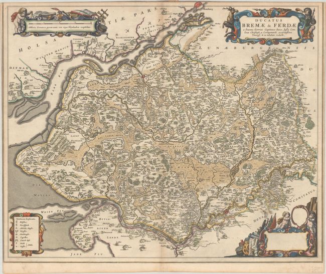
"Ducatus Bremae & Ferdae a Ioanne Gorries Capitaneo Sueco Jussu Com. Ioan Christoph. a Coningsmarck Accuratissime Dimensi & in Tabulam Redacti", Blaeu, Johannes
Subject: Northwestern Germany
Period: 1659 (circa)
Publication:
Color: Hand Color
Size:
24.6 x 20.2 inches
62.5 x 51.3 cm
Download High Resolution Image
(or just click on image to launch the Zoom viewer)
(or just click on image to launch the Zoom viewer)
This map details the region between Hamburg and Bremen and the Elbe and Wesel Rivers. Although the map doesn't show the cardinal directions, north is oriented to the top left of the map. There is excellent detail of islands within the rivers and their tributaries, as well as the forests and marshes in the area. Superb strapwork cartouches fill the corners of the map featuring putti, surveying tools, a hunter and his prey, and symbols of war. Spanish test on verso, published between 1659-72.
References: Van der Krogt (Vol. II) #2240:2.1.
Condition: B+
Excellent impression with full contemporary color on a bright, watermarked sheet with very light soiling and two tiny wormholes near the center of the image. Trimmed to the neatline at top and left by the bookbinder, with part of the neatline missing at top.
Estimate: $190 - $220
Price: $140
Bid Increments
$100 - $249$10
$250 - $499$25
$500 - $999$50
$1,000 - $2,499$100
Terms & Conditions