Current Auction
One of the Most Decorative 18th Century World Maps
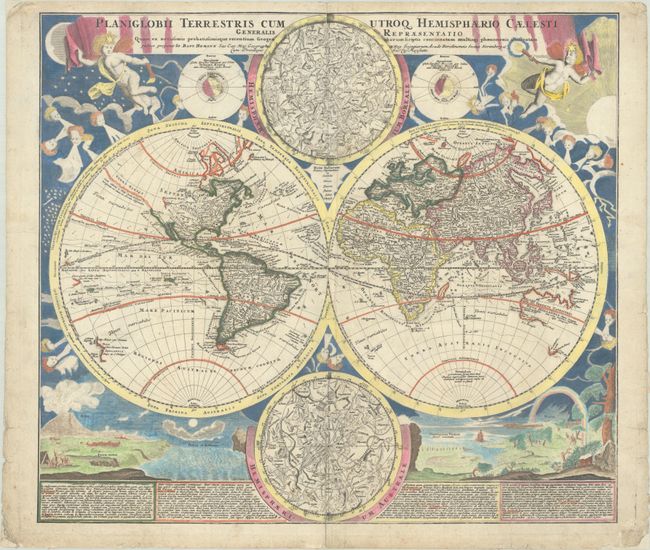
"Planiglobii Terrestris cum Utroq Hemisphaerio Caelesti Generalis Repraesentatio quam ex Novissimis Probatissimisque Geographorum...", Homann, Johann Baptist
Subject: World
Period: 1720 (circa)
Publication:
Color: Hand Color
Size:
21.3 x 18.8 inches
54.1 x 47.8 cm
Download High Resolution Image
(or just click on image to launch the Zoom viewer)
(or just click on image to launch the Zoom viewer)
This is one of the most decorative eighteenth century world maps. The two hemispheres are surrounded by vivid engravings of natural phenomena such as a rainbow, earthquakes, and a volcano. Wind heads occupy the starry heavens, and two putti hold the title banner aloft. The map itself shows a typical geographical view of the period. An indistinct Terra Esonis appears above California, here depicted as a peninsula. The partial coastlines of Australia, New Zealand, and New Guinea are noted. Australia is shown to be separate from New Guinea, Carpentaria and Van Diemen's Land. Nova Britannia is shown as a separate island off the coast of New Guinea with the notation that it was discovered by Dampier in 1700. Several explorer's tracks are traced, including Magellan, Dampier, Tasman, Gaetani and Charmont. Nestled between the hemispheres are two detailed celestial maps. Text panels at bottom describe the natural phenomena. Homann borrowed both the cartography and depictions of natural phenomenon from Zurner's similar map circa 1700.
References:
Condition: B+
Issued on watermarked paper with short archivally repaired centerfold separations at top and bottom. There is some minor colorist's ink residue in the celestial sphere at top and a number of short archivally repaired edge tears and chips confined to the blank margins.
Estimate: $1,800 - $2,200
Current High Bid:
$0
Reserve: Reserve Not Met
Next Bid: $900
Bid Increments
$500 - $999$50
$1,000 - $2,499$100
$2,500 - $4,999$250
$5,000 - $9,999$500
Terms & Conditions