Current Auction
"L'Amerique Divisee en ses Principaux Etats, Assujetie aux Observations Astronomiqes", Janvier/Lattre
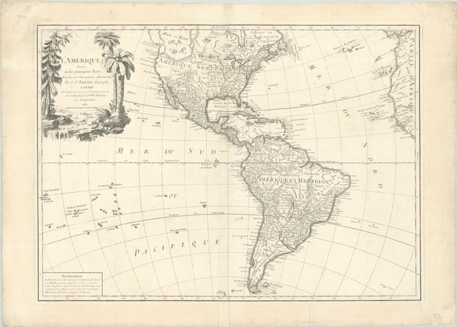
Subject: Western Hemisphere - America
Period: 1784 (dated)
Publication:
Color: Black & White
Size:
26 x 18.8 inches
66 x 47.8 cm
Download High Resolution Image
(or just click on image to launch the Zoom viewer)
(or just click on image to launch the Zoom viewer)
The most striking feature of this large, handsome map of North and South America is the huge Sea of the West. It is so massive that the northern portion of this mythical sea is not shown. Two entrances from the Pacific are noted: by Juan De Fuca in 1592 and by Martin d'Aguilar in 1603. It is connected by a series of rivers to Hudson Bay in the north and nearly connects to the Mississippi River in the south, thus presenting one of the most elaborate Northwest Passages of maps from this period. The balance of the map includes a myriad of information on cities, political boundaries, and river systems. The large decorative title cartouche, engraved by P.P. Choffard, shows a stream filled with unusual beaver dams and pine trees on one bank and palm trees on the other.
References: McGuirk #88.
Condition: A
A nice impression on a bright sheet with a rosary beads watermark. There are a few expertly repaired tears in wide margins and minor soiling.
Estimate: $350 - $425
Current High Bid:
$0
Reserve: Reserve Not Met
Next Bid: $180
Bid Increments
$100 - $249$10
$250 - $499$25
$500 - $999$50
$1,000 - $2,499$100
Terms & Conditions