Current Auction
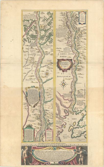
Blaeu's Strip-Map of the Dnieper River
"[Campus Inter Bohum et Borystenem] Lectori S. Hunc Borysthenis Tractum ut ad Nostrum Geographiae Tabulam…", Blaeu, (Family)
Subject: Dnieper River, Ukraine
Period: 1634 (published)
Publication: Novus Atlas
Color: Hand Color
Size:
12.8 x 29.6 inches
32.5 x 75.2 cm
Download High Resolution Image
(or just click on image to launch the Zoom viewer)
(or just click on image to launch the Zoom viewer)
This superb, large map traces the course of the Dnieper River from Cherkasy to the estuary on the Black Sea. The map is in strip style with two vertical maps following the course of the river, each decorated with cartouches and compass roses and including numerous lengthy notations describing the cataracts, cities, salt mines, fortresses, and the historical traditions of the Cossacks. Putti flank a large cartouche at bottom. This map is based on an inset map from the important Radziwill-Makowski map of the Duchy of Lithuania (1613), which was the most accurate map of Lithuania and served as a resource for all other maps of the region for 150 years. Blaeu first published the map, along with the inset of the Dnieper River, as a four-sheet map in his Appendix in 1631. The map of Lithuania and the strip map of the Dnieper River then appeared separately in subsequent Blaeu atlases. Engraved by Hessel Gerritsz. Two sheets joined, as issued. German text on verso..
References: Kordan (Ukraine) #9; Ukraine in Old Maps pp. 188-89; Van der Krogt (Vol. II) #1730/II:2A.
Condition: B+
A fine impression with full contemporary color. There are a few small stains on the northern sheet, minor toning on the southern sheet, light soiling that is largely confined to the blank margins, and short edge tears in the blank margins that have been repaired on verso with archival materials.
Estimate: $1,400 - $1,700
Current High Bid:
$0
Reserve: Reserve Not Met
Next Bid: $700
Bid Increments
$500 - $999$50
$1,000 - $2,499$100
$2,500 - $4,999$250
$5,000 - $9,999$500
Terms & Conditions