Current Auction
"Nouveau Mexique, Louisiane, Canada, et Nlle. Angleterre", Brion de la Tour/Desnos
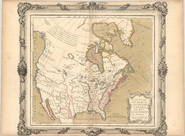
Subject: Colonial North America
Period: 1766 (dated)
Publication:
Color: Hand Color
Size:
12.4 x 11.1 inches
31.5 x 28.2 cm
Download High Resolution Image
(or just click on image to launch the Zoom viewer)
(or just click on image to launch the Zoom viewer)
This decorative map covers the majority of the continent, excluding Alaska and southern Mexico. The Northwest region is mostly blank except for notations concerning the recent discoveries by Bering, Tschirikow, and De Fuente. A River of the West is shown flowing out of Lake Winnipeg and another major river is depicted emptying into San Francisco Bay. Quivira is located in present-day Nevada just below Nouvelle Albion suivant Drake. The British Colonies are confined to the eastern seaboard. The map features a decorative title cartouche and is surrounded by a lovely rococo-style frame that was printed from a separate plate. Brion was the former Geographer to the King of France, and Desnos was Geographer to the King of Denmark.
References:
Condition: B+
A dark impression with full contemporary color, toning along the centerfold, some color offsetting at far right, and two small worm holes in the image. Trimmed at top and bottom by the bookbinder with minor loss of the engraved border.
Estimate: $200 - $230
Current High Bid:
$100
Reserve: Reserve Not Met
Next Bid: $110
Bid Increments
$100 - $249$10
$250 - $499$25
$500 - $999$50
$1,000 - $2,499$100
Terms & Conditions