Current Auction
"North America Drawn from the Best Authorities", Kitchin, Thomas
Subject: Colonial North America
Period: 1783 (circa)
Publication: A New Geographical, Historical, and Commercial Grammar
Color: Hand Color
Size:
8.9 x 7.6 inches
22.6 x 19.3 cm
Download High Resolution Image
(or just click on image to launch the Zoom viewer)
(or just click on image to launch the Zoom viewer)
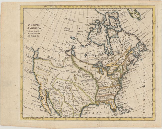
The unexplored northwestern regions remain largely blank on this map of North America, but below the title there is still a wide variety of speculative cartography. The Western Sea has only the western coastline delineated and the entrances are noted as discovered by Juan de Fuca and Aguilar. The River of the West also apparently ties into this vague sea and is connected by a dotted line to Pikes Lake and Mantons R. There is an east-west range of mountains below New Albion labeled the Snowy Mountains. A river in the approximate location of the Colorado is called Martyr's R. The inter-mountain region is labeled Teguayo & Quivira, and central Canada has a bizarre system of lakes and rivers. Locates many Indian tribes, Buffalo Meadows, forts, etc. The British colonies are shown with their western boundaries on the Mississippi River. Published in William Guthrie's A New Geographical, Historical, and Commercial Grammar with the decorative cartouche removed from previous editions.
References: McCorkle (18th C. Geography Books) #165; McGuirk #172.
Condition: A
A nice impression issued folding, now flat, with contemporary outline color on a faintly toned sheet.
Estimate: $220 - $250
Current High Bid:
$110
Reserve: Reserve Not Met
Next Bid: $120
Bid Increments
$100 - $249$10
$250 - $499$25
$500 - $999$50
$1,000 - $2,499$100
Terms & Conditions