Current Auction
"Totius Terrae Sanctae Delineatio", Cluver, Philipp
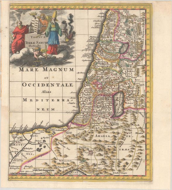
Subject: Holy Land
Period: 1697 (published)
Publication: Introductio in Universam Geographiam
Color: Hand Color
Size:
8.4 x 10.4 inches
21.3 x 26.4 cm
Download High Resolution Image
(or just click on image to launch the Zoom viewer)
(or just click on image to launch the Zoom viewer)
This charming small map of the Holy Land extends to Egypt and shows the route of the Children of Israel in their exodus from Egypt to the Promised Land. The map is finely engraved and filled with a surprising amount of detail. The large title cartouche shows Moses with the Commandments, Aaron, an angel carrying a crown, and a blindfolded putto representing Justice.
Cluver's Introductio in Universam Geographicam was a popular atlas, appearing in over 45 editions during a 100-year period. The first edition was published without maps in the 1620s, and the first edition to include maps was published circa 1641. The various editions were published in different cities throughout Europe, including Amsterdam, Nuremberg, and London, often with new sets of maps engraved. This map is from an Amsterdam edition published by Jan Wolters.
References: cf. Laor #216; Shirley (BL Atlases) T.CLUV-8a #38.
Condition: A
A crisp impression, issued folding. The top margin is narrow, as issued, and a binding trim at left has been professionally replaced with old paper.
Estimate: $140 - $170
Current High Bid:
$100
Reserve: Reserve Met
Next Bid: $110
Bid Increments
$100 - $249$10
$250 - $499$25
$500 - $999$50
$1,000 - $2,499$100
Terms & Conditions