Current Auction
"Het Beloofde Landt Canaan door Wandelt van Onsen Salichmaecker Iesu Christo, Neffens Syne Apostelen", Stoopendaal, Daniel
Subject: Holy Land
Period: 1729 (circa)
Publication:
Color: Black & White
Size:
18 x 13.8 inches
45.7 x 35.1 cm
Download High Resolution Image
(or just click on image to launch the Zoom viewer)
(or just click on image to launch the Zoom viewer)
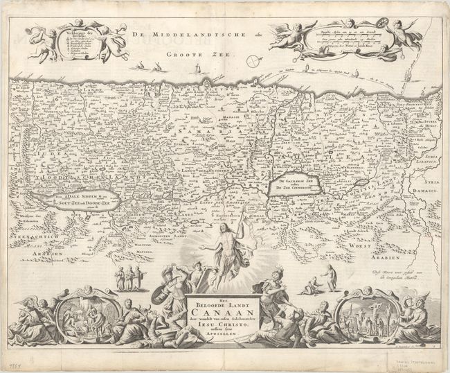
Graphic map of Israel filled with biblical scenes. A compass rose orients the map with north in the top right corner. The large decorative title cartouche at bottom is surrounded by a dramatic scene of the resurrected Christ ascending to Heaven while Roman soldiers draw back in fright. The four evangelists flank vignettes depicting the life of Christ, including his birth and crucifixion. At top, putti hold banners with the key to the map and scale of miles, and tiny ships and the track of Apostle Paul are shown in the sea. This is the 4th state, published by Pieter and Jacob Keur, whose names appear in the distance scale cartouche. Dutch text on verso.
References: Poortman & Augusteijn #134-GII-3.
Condition: B+
Issued folding with folds reinforced with tissue on verso. There is light soiling mostly confined to the blank margins, and professional repairs to a small hole below the cartouche at top left and to some small chips and tears in the top margin.
Estimate: $140 - $170
Current High Bid:
$0
Reserve: Reserve Not Met
Next Bid: $70
Bid Increments
$50 - $99$5
$100 - $249$10
$250 - $499$25
$500 - $999$50
Terms & Conditions