Current Auction
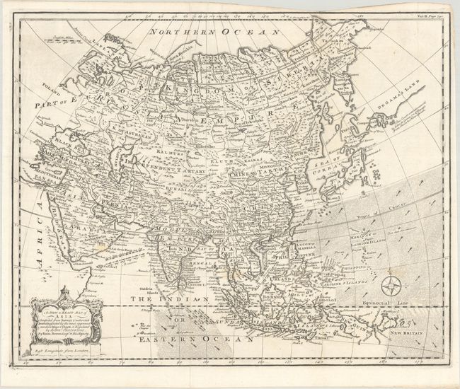
"A New & Exact Map of Asia Compiled from Surveys & Authentick Journals, Assisted by the Most Approved Modern Maps & Charts, & Regulated by Astronl. Observations", Bowen, Emanuel
Subject: Asia
Period: 1744 (circa)
Publication: Navigantium atque Itinerantium Bibliotheca...
Color: Black & White
Size:
18 x 14.5 inches
45.7 x 36.8 cm
Download High Resolution Image
(or just click on image to launch the Zoom viewer)
(or just click on image to launch the Zoom viewer)
This finely engraved map of the continent is dense with information. Kamchatka appears as a squat peninsula above the island of vaguely delineated Yedso (Hokkaido). To the east of Yedso is Companys Ld. and a large landmass labeled De Gama's Land, named for the Portuguese captain Joao da Gama, who reported sighting land in the northern Pacific in 1589-90. The Sea of Japan is named the Sea of Corea. The direction of trade winds and monsoons are graphically depicted with arrows in the oceans. The map is decorated with an ornate title cartouche and a nice compass rose. Published in John Harris' Navigantium atque Itinerantium Bibliotheca. Or, a Complete Collection of Voyages and Travels...
References: Shirley (BL Atlases) G.HARR-1a #24.
Condition: A
A crisp impression issued folding on a bright sheet with the watermarks of "VI" and a fleur-de-lis. There are faint stains in Arabia and above the compass rose.
Estimate: $190 - $220
Current High Bid:
$0
Reserve: Reserve Not Met
Next Bid: $95
Bid Increments
$50 - $99$5
$100 - $249$10
$250 - $499$25
$500 - $999$50
Terms & Conditions