Current Auction
"[Lot of 2] La Grande Tartarie [and] Great or Asiatick Tartary. Agreable to Modern History"
Subject: Northern Asia, Russia
Period: 1683-1726 (circa)
Publication:
Color: Hand Color
Size:
See Description
Download High Resolution Image
(or just click on image to launch the Zoom viewer)
(or just click on image to launch the Zoom viewer)
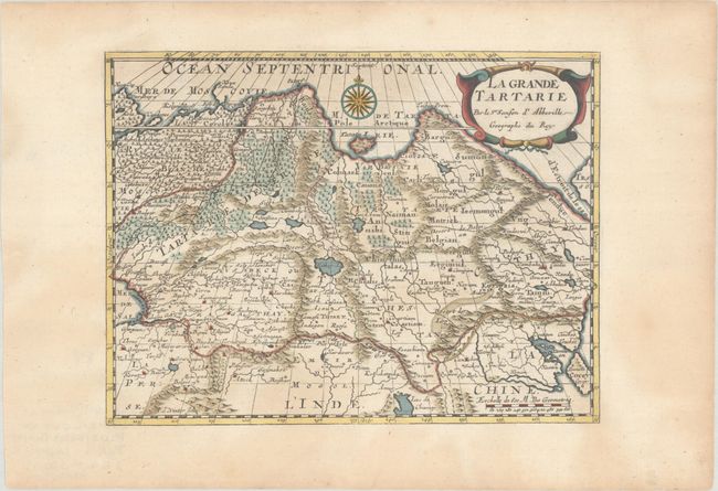
A. La Grande Tartarie, by Nicolas Sanson, circa 1683 (9.9 x 7.4"). Attractive map of Siberia, northern China, and Korea, which is shown here as an island. The cities, mountains, forests and rivers are well-detailed. Siberia still reflects some of Ptolemy’s conceptions with the Island of Tazata and the Cape of Tabin in the extreme north. The map is decorated with a lovely title cartouche as well as a beautiful compass rose. Engraved by Antoine d'Winter.
Sanson's small maps from his L'Asie en Plusieurs Cartes..., first published in 1652 and engraved by A. Peyrounin, were copied several times by various map publishers. Johann David Zunners made copies of Sanson's maps for his German translation of Die Gantze Erd-Kugel in 1679. Johannes Ribbius and Simon de Vries published copies in 1682 and 1683, with new maps engraved by Antoine d'Winter. The plates were later sold to Francois Halma, who used them in 1699 and then again in 1705 with the titles re-engraved in Dutch. The titles on the d'Winter plates were re-engraved back into French, and then used by Nicholas Chemereau in 1715 and by Henri du Sauzet in 1738. Condition: A crisp impression with minor toning that is mostly confined to the blank margins.
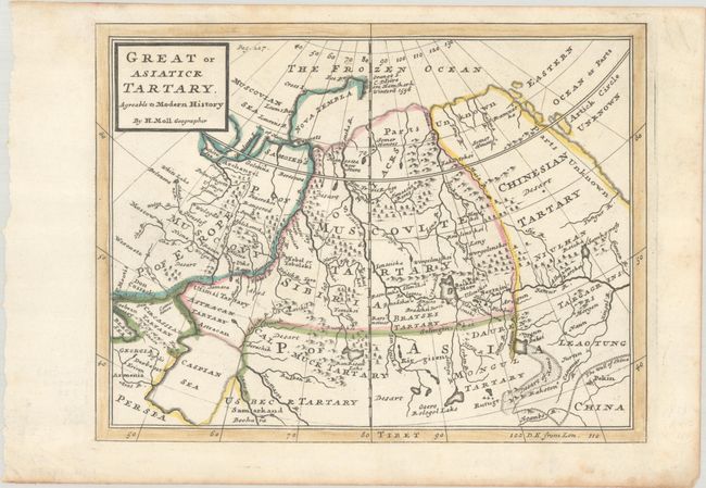
B. Great or Asiatick Tartary. Agreable to Modern History, by Herman Moll, from Modern History, published 1726 (10.3 x 7.9"). This handsome map spans from Moscow and the Caucasus past Chinesian Tartary to the ill-defined eastern edge of the continent, simply labeled Parts Unknown. Place names, deserts, and topographical details dot the landscape. The Caspian Sea is shown in a squat configuration with a conjectural coastline to the north and east, and Pekin and the Great Wall of China appear in the southeast corner of the map. The coastline of Nova Zembla is incomplete. Much of the northeastern part of the continent is still unexplored, with a strictly conjectural coastline from Nova Zembla to Tungur R. (the Tungir). Engraved in Moll's fine, distinctive style. "Pag. 227" appears to the right of the title cartouche. Reference: McCorkle (18th C. Geography Books) #346, Vol IV [2]. Condition: A crisp impression on watermarked paper with marginal foxing at bottom.
References:
Condition: A
See description above.
Estimate: $140 - $170
Current High Bid:
$70
Reserve: Reserve Not Met
Next Bid: $75
Bid Increments
$50 - $99$5
$100 - $249$10
$250 - $499$25
$500 - $999$50
Terms & Conditions