Current Auction
Large-Scale Map of Eastern Asia Focusing on China
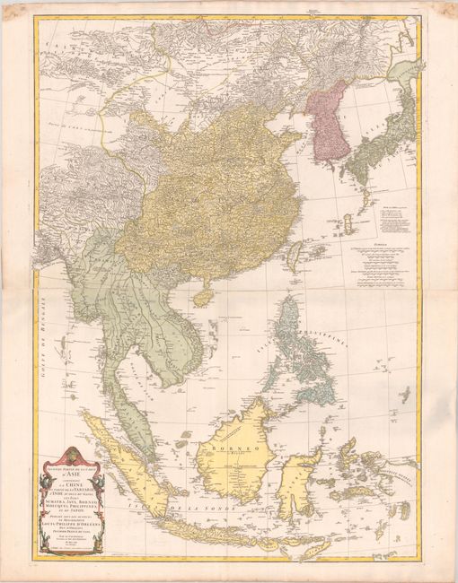
"Seconde Partie de la Carte d'Asie Contenant la Chine et Partie de la Tartarie, l'Inde au dela du Gange, les Isles Sumatra, Java, Borneo, Moluques, Philippines, et du Japon", Anville, Jean Baptiste Bourguignon d'
Subject: Eastern Asia
Period: 1752 (dated)
Publication:
Color: Hand Color
Size:
27.6 x 38.5 inches
70.1 x 97.8 cm
Download High Resolution Image
(or just click on image to launch the Zoom viewer)
(or just click on image to launch the Zoom viewer)
This remarkably detailed map covers eastern Asia, including China, Korea, Japan, and Southeast Asia. The primary focus of the map is China, which is depicted in tremendous detail, with hundreds of tiny villages, political boundaries, rivers, and topography. Hokkaido, here named Jeso-Gasima has a rudimentary shape and is nearly devoid of geographical information. There is less geographical detail in Southeast Asia. The interior of Borneo is noted as "occupied by the savage nation of the Biayos" and the northeast portion of the island is "less well known" than the rest of the island. Sulawesi is poorly defined and quite rotund, while New Guinea is only partially delineated. The very northern tip of Australia is labeled as Terre du Sud. Engraved by Guillaume de la Haye. On two sheets joined together.
References:
Condition: A
A crisp impression on a bright sheet of watermarked paper with a pair of dampstains confined to the top blank margin.
Estimate: $1,100 - $1,400
Current High Bid:
$0
Reserve: Reserve Not Met
Next Bid: $550
Bid Increments
$500 - $999$50
$1,000 - $2,499$100
$2,500 - $4,999$250
$5,000 - $9,999$500
Terms & Conditions