Current Auction
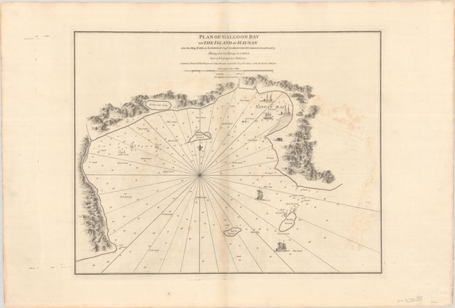
"Plan of Galloon Bay on the Island of Hay-Nan Where the Ship Earl of Sandwich Capt. Charles Deane Wintered in 1776 and 77 Having Lost Her Passage to China...", Sayer & Bennett
Subject: Hainan, China
Period: 1781 (dated)
Publication: The East-India Pilot
Color: Black & White
Size:
25 x 19.7 inches
63.5 x 50 cm
Download High Resolution Image
(or just click on image to launch the Zoom viewer)
(or just click on image to launch the Zoom viewer)
This lovely chart depicts Yalong Bay along the southern coast of Hainan, and is filled with detail of depth soundings, rocks, shoals, and safe anchorages. The bottom types within the bay are noted, including sand, gravel, blue clay and "soft ground." The topography along the coastline is also depicted, along with two small settlements. Five masted ships sail in the bay and rhumb lines radiate from a small fleur-de-lis. This chart is attributed to Captain John Haldane, who conducted a survey of the bay on behalf of the British East India Company while en route to Canton.
References: Shirley (BL Atlases) M.SAY-3a #90.
Condition: B
A dark impression on a sturdy sheet with some offsetting, light toning along the centerfold, minor soiling, and remnants of hinge tape on verso.
Estimate: $800 - $950
Current High Bid:
$0
Reserve: Reserve Not Met
Next Bid: $400
Bid Increments
$250 - $499$25
$500 - $999$50
$1,000 - $2,499$100
$2,500 - $4,999$250
Terms & Conditions