Current Auction
"Amerique Septentrionale", Lorrain, N. Pere
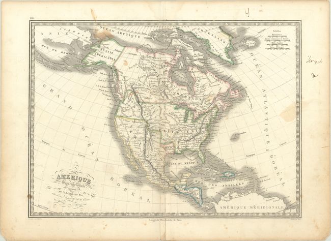
Subject: North America, Texas
Period: 1839 (circa)
Publication: Depot de la Guerre
Color: Hand Color
Size:
14.9 x 10.9 inches
37.8 x 27.7 cm
Download High Resolution Image
(or just click on image to launch the Zoom viewer)
(or just click on image to launch the Zoom viewer)
This uncommon copper-engraved map features the Independent Republic of Texas nestled between the United States and a large Mexico. Texas is in an odd configuration with the western border displaced too far to the east from the Rio Grande River, putting San Antonio and Santa Fe in Mexico. The Rocky Mountains are called the Montagues Rochieuses. The Great Salt Lake is called Lake Timpanogos with the smaller Lake Teguyao below. Several spurious river systems cross the Great Basin area. This French map portrays the United States extending well into British Columbia, which was eventually known as the Fifty-four Forty or Fight controversy, cartographically taking the side of the United States. Alaska is Russie Americaine, and all of Canada is Nouvelle Bretagne. Fancy titling with flourishes and a keyboard-style border embellish the map. Engraved by Lale.
References:
Condition: B
Contemporary outline color with some light staining and an extraneous crease adjacent to the centerfold.
Estimate: $160 - $190
Current High Bid:
$0
Reserve: Reserve Not Met
Next Bid: $80
Bid Increments
$50 - $99$5
$100 - $249$10
$250 - $499$25
$500 - $999$50
Terms & Conditions