Current Auction
"Africa, Antiqua, et Nova", Cluver, Philipp
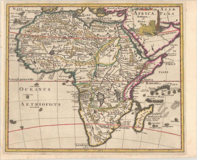
Subject: Africa
Period: 1697 (published)
Publication: Introductio in Universam Geographiam
Color: Hand Color
Size:
10.1 x 8.4 inches
25.7 x 21.3 cm
Download High Resolution Image
(or just click on image to launch the Zoom viewer)
(or just click on image to launch the Zoom viewer)
An interesting continental map that is very similar to Sanson's Africa Vetus. Well engraved with few place names in the south and only the major river systems and mountains shown. The Nile originates from two large lakes well south of the Equator in the Ptolemaic style. The title cartouche includes a fierce lion. This is the first state, with "Tab. 43" at top right.
Cluver's Introductio in Universam Geographicam was a popular atlas, appearing in over 45 editions during a 100-year period. The first edition was published without maps in the 1620s, and the first edition to include maps was published circa 1641. The various editions were published in different cities throughout Europe, including Amsterdam, Nuremberg, and London, often with new sets of maps engraved. This map is from an Amsterdam edition published by Jan Wolters.
See also lot 788 for Richard Betz's The Mapping of Africa - A Cartobibliography of Printed Maps of the African Continent to 1700 that describes this map.
References: Betz #166; Shirley (BL Atlases) T.CLUV-8a #40.
Condition: A
A dark impression, issued folding on a sheet with a large watermark of the Amsterdam arms. The top margin is narrow, as issued.
Estimate: $180 - $210
Current High Bid:
$0
Reserve: Reserve Not Met
Next Bid: $90
Bid Increments
$50 - $99$5
$100 - $249$10
$250 - $499$25
$500 - $999$50
Terms & Conditions