Current Auction
"Particular Draughts of Some of the Chief African Islands in the Mediterranean, as Also in the Atlantic and Ethiopic Oceans", Bowen, Emanuel
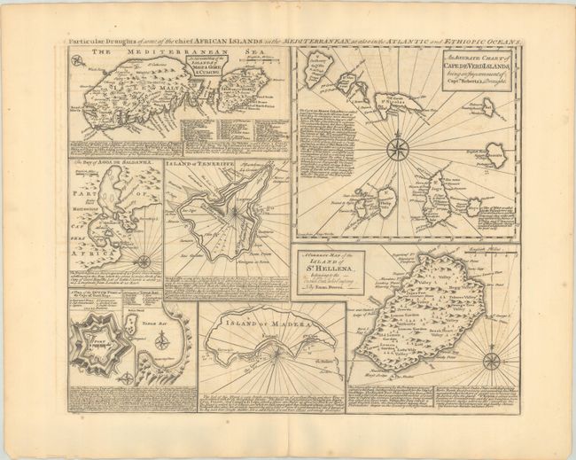
Subject: African Islands, Malta
Period: 1747 (circa)
Publication: A Complete System of Geography
Color: Black & White
Size:
16.8 x 13.7 inches
42.7 x 34.8 cm
Download High Resolution Image
(or just click on image to launch the Zoom viewer)
(or just click on image to launch the Zoom viewer)
This sheet includes 8 separate small maps, primarily focused on islands around, or a part of, Africa. The maps include: An Accurate Map of the Islands of Malta Goze & Cuming; An Accurate Chart of Cape de Verd Islands...; The Bay of Agoa de Saldanha; Island of Teneriffe; A Plan of the Dutch Fort at the Cape of Good Hope; A Draught of Table Bay; Island of Madera; and A Correct Map of the Island of St. Hellena... Each map features place names, topographical information, a compass rose, and descriptive English text.
References: McCorkle (18th C. Geography Books) #17, Vol. II [20]; Norwich #338; Shirley (BL Atlases) T.BOW-2a #50.
Condition: B+
A dark impression on a sheet with the watermarks of papermaker Lubbert van Gerrevink and "VI". There are a few small spots, light offsetting, and a centerfold separation in the bottom blank margin that has been closed with old paper on verso.
Estimate: $200 - $230
Current High Bid:
$110
Reserve: Reserve Not Met
Next Bid: $120
Bid Increments
$100 - $249$10
$250 - $499$25
$500 - $999$50
$1,000 - $2,499$100
Terms & Conditions