Current Auction
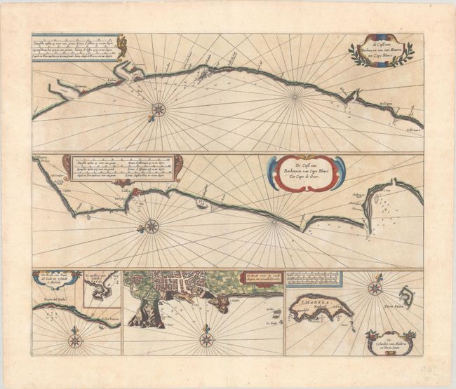
"De Cust van Barbaryen van out Mamora tot Cap Blanco [on sheet with] De Cust van Barbaryen van Cap Blanco tot Capo de Geer [and] De Reede van Punte del Gada... [and] De Reede voor de Stadt Angra... [and] De Eylanden van Madera en Porto Santo", Goos, Pieter
Subject: Morocco, Azores & Madeira
Period: 1666 (circa)
Publication: De Zee-Atlas Ofte Water-Weereld
Color: Hand Color
Size:
20.8 x 17.2 inches
52.8 x 43.7 cm
Download High Resolution Image
(or just click on image to launch the Zoom viewer)
(or just click on image to launch the Zoom viewer)
This handsome chart includes 2 larger maps of portions of the Barbary Coast of Morocco, as well as three smaller charts of the Azores and Madeira archipelagos. The two charts of Morocco depict the coastline surrounding Safi and Sale. Each chart includes a compass rose for orientation, depth soundings, and anchorages, and is embellished with a decorative cartouche and rhumb lines.
References:
Condition: B+
A sharp impression with very light toning. There are archival repairs to some small chips and tears along the edges of the sheet, none of which affect the image.
Estimate: $500 - $650
Current High Bid:
$0
Reserve: Reserve Not Met
Next Bid: $250
Bid Increments
$250 - $499$25
$500 - $999$50
$1,000 - $2,499$100
$2,500 - $4,999$250
Terms & Conditions