Current Auction
Rare Chart of Western Africa from The Burning Fen
"De Cust van Gambia Tusschen Rio Senegael en Rio Cazamansa", Robijn (Robyn), Jacobus
Subject: Western Africa
Period: 1685 (circa)
Publication: 't Vierde Deel van de Nieuwe Groote Zee-Spiegel...
Color: Black & White
Size:
19.5 x 16.3 inches
49.5 x 41.4 cm
Download High Resolution Image
(or just click on image to launch the Zoom viewer)
(or just click on image to launch the Zoom viewer)
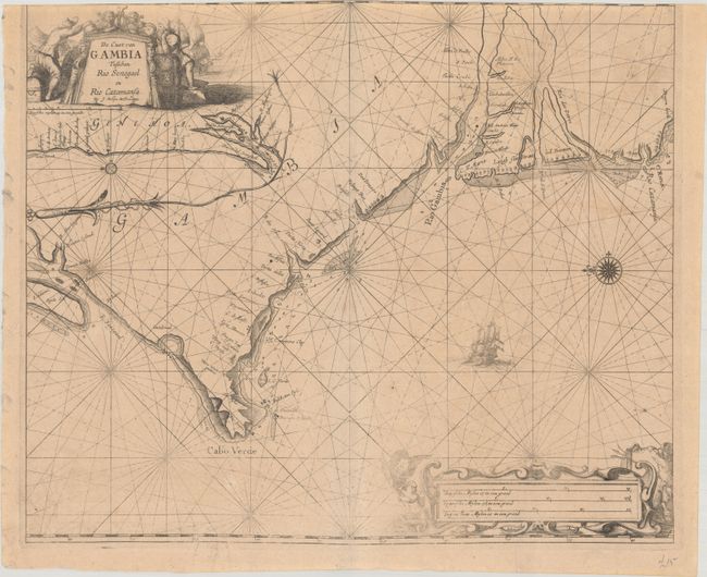
This rare sea chart covers the coast of present-day Senegal and the Gambia. It was published by Robijn in the second part of The Burning Fen, which covers the coasts of western Africa and Brazil. The map spans the coast from the mouth of the Senegal River south to Cabo Verde, the River Gambie, and the Casamance River. An inset beneath the title cartouche extends coverage farther north. Navigational information such as soundings, anchorages, and shoals are noted. A sailing ship appears in a sea crisscrossed by rhumb lines. At top left, the allegorical title cartouche depicts a coastal scene with symbols of prosperity and trade. The distance scale cartouche at bottom right is flanked by a putto with a flag and another with a trident and conch. A compass rose orients north to the left.
The charts of The Burning Fen were the work of Arent Roggeveen, a land surveyor and mathematician who taught navigation for the Dutch East and West India Companies. He also helped maintain their collection of hydrographic manuscripts and charts. According to Koeman, "He was the first Dutch chartmaker who succeeded in the publication of a printed set of charts for the Navigation in the Atlantic, along the coast of West Africa and in the West Indies." The first part of Het Brandende Veen or The Burning Fen was published by Pieter Goos in 1675 (the same year of his death). With its charts of Central American coastlines and islands, it was the first pilot book to include non-European coasts. After Roggeveen died in 1679, Jacob Robijn took over the rights to Roggeveen's plates. He published the second part of The Burning Fen in 1685. Although Roggeveen is still credited on the title page and the charts of Africa are likely based on his manuscripts, the maps are signed by Robijn. Both parts of The Burning Fen are extremely rare. This is the first time we have seen this chart on the market.
References: Koeman, Rog 12 #6.
Condition: B
The impression is a bit faint at bottom right. On a lightly toned sheet with a couple of tiny wormtracks along the centerfold at bottom, light offsetting, and minor creasing at bottom. Trimmed at top with loss of most of the top border.
Estimate: $400 - $500
Current High Bid:
$0
Reserve: Reserve Not Met
Next Bid: $200
Bid Increments
$100 - $249$10
$250 - $499$25
$500 - $999$50
$1,000 - $2,499$100
Terms & Conditions