Current Auction
"A Large Chart of the North Coast of Guinea from Cape de Verd to Sherbro", Mount & Page
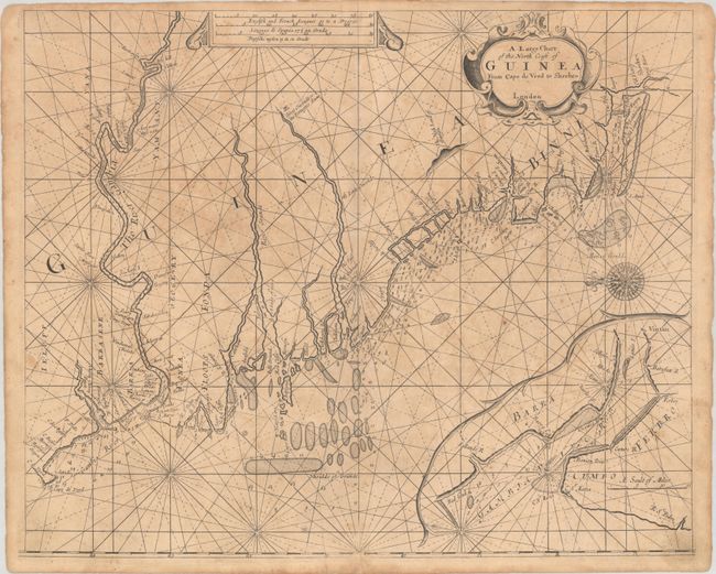
Subject: Western Africa
Period: 1766 (circa)
Publication: The English Pilot: Part V
Color: Black & White
Size:
21 x 17.3 inches
53.3 x 43.9 cm
Download High Resolution Image
(or just click on image to launch the Zoom viewer)
(or just click on image to launch the Zoom viewer)
This rare English sea chart spans from Cap-Vert or Cape Verde south to Sherbro Island. There are several place names lining the coast as well as small islands and rivers. The River Gambie is prominently depicted on the main map, with its entrance shown in even greater detail in an inset at bottom right. Rhumblines, depth soundings, hazards, and shoals fill the water. Interesting inland notations include "Great Couconda or the Portugees Towne" in Guinea and "The High Land of Sawsasu," illustrated with a mountain range to the northwest of the Sierra Leone River. An elaborate compass rose orients the north to the left. The map is adorned with an ornate strapwork title cartouche and a distance scale cartouche, both at top. From a later edition of The English Pilot.
References: Rumsey #14347.030.
Condition: B
On a sheet with a Strasburg bend & lily watermark and a printer's crease at bottom center. There is moderate foxing, light soiling, and a 1.5" centerfold separation at bottom that has been repaired with archival materials on verso.
Estimate: $160 - $190
Current High Bid:
$0
Reserve: Reserve Not Met
Next Bid: $80
Bid Increments
$50 - $99$5
$100 - $249$10
$250 - $499$25
$500 - $999$50
Terms & Conditions