Current Auction
"La B.N.C.I en Afrique Occidentale & Equatoriale Francaise"
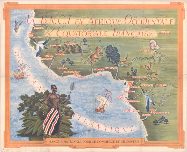
Subject: Western Africa
Period: 1950 (circa)
Publication:
Color: Printed Color
Size:
20.7 x 16.8 inches
52.6 x 42.7 cm
Download High Resolution Image
(or just click on image to launch the Zoom viewer)
(or just click on image to launch the Zoom viewer)
This pictorial map of western Africa was published by the Banque Nationale Pour le Commerce et l'Industrie (BNCI). It covers much of French West Africa, extending from St. Louis, Senegal down to Pointe Noire, Congo. The map locates and names several cities in the region, and 4 Caducei symbols (often used to represent commerce) presumably symbolize bank branches. The composition is beautifully decorated by a variety of plants and animals including a lion, elk, and cranes while a native warrior surveys the coastline. Surrounded by a picture frame border. Printed by Draeger in Paris.
References:
Condition: B+
Folded by a previous owner and now flattened and backed with tissue to repair a 3" edge tear at right and a few short fold separations. There is some minor soiling in the bottom blank margin.
Estimate: $350 - $425
Current High Bid:
$0
Reserve: Reserve Not Met
Next Bid: $180
Bid Increments
$100 - $249$10
$250 - $499$25
$500 - $999$50
$1,000 - $2,499$100
Terms & Conditions