Current Auction
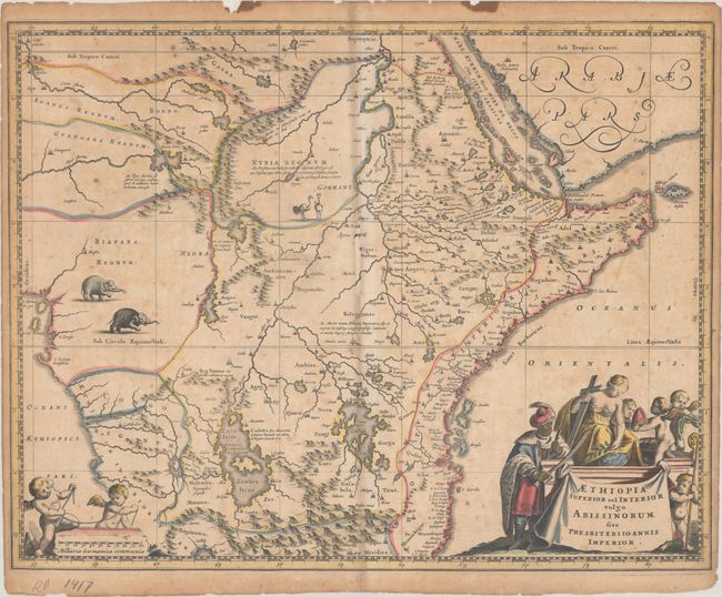
"Aethiopia Superior vel Interior Vulgo Abissinorum sive Presbiteri Ioannis Imperior", Dapper, Olivier
Subject: Central Africa
Period: 1670 (circa)
Publication: Naukeurige Beschrijvinge der Afrikaensche
Color: Hand Color
Size:
14.4 x 11.4 inches
36.6 x 29 cm
Download High Resolution Image
(or just click on image to launch the Zoom viewer)
(or just click on image to launch the Zoom viewer)
Decorative map of eastern and central Africa depicting the legendary Christian kingdom of Prester John. It is based on an earlier map by Blaeu with a fair amount of detail on the eastern coast, reflecting colonial trading interests. The Nile is shown originating in the twin Ptolemaic lakes of Zaire and Zaflan. The map is decorated in the interior elephants and ostriches, while the title cartouche is an original design representing the king's conversion to Christianity.
The legend of Prester John began about 1150 A.D. when rumor spread throughout Europe that there was a powerful Christian kingdom in Asia that had defeated the enemies of Christianity at a time when there were tremendous Mongol and Islamic pressures on Europe. Several popes attempted to contact the mysterious Priest-King but the kingdom was never located in Asia. The popular fancy was not easily dispelled, and the myth was simply moved to Africa and the legend persisted. Abraham Ortelius was the first to devote a map to the mysterious kingdom and it was a standard map of central Africa throughout the seventeenth century.
References:
Condition: B
A crisp impression on a moderately toned sheet with the watermarks of a horse and the initials "AP." There is light offsetting, minor foxing, and a narrow sliver of the centerfold at the center that has been replaced with old paper with a minute amount of image replaced in facsimile. There are two small stains along the top edge of the sheet and some small chips and tears along the top edge have been closed on verso with archival tape.
Estimate: $200 - $230
Current High Bid:
$0
Reserve: Reserve Not Met
Next Bid: $100
Bid Increments
$100 - $249$10
$250 - $499$25
$500 - $999$50
$1,000 - $2,499$100
Terms & Conditions