Current Auction
The First Printed Map Devoted to the Pacific in Full Contemporary Color
"Maris Pacifici, (quod Vulgo Mar del Zur) cum Regionibus Circumiacentibus, Insulisque, in Eodem Passim Sparsis, Novissima Descriptio", Ortelius, Abraham
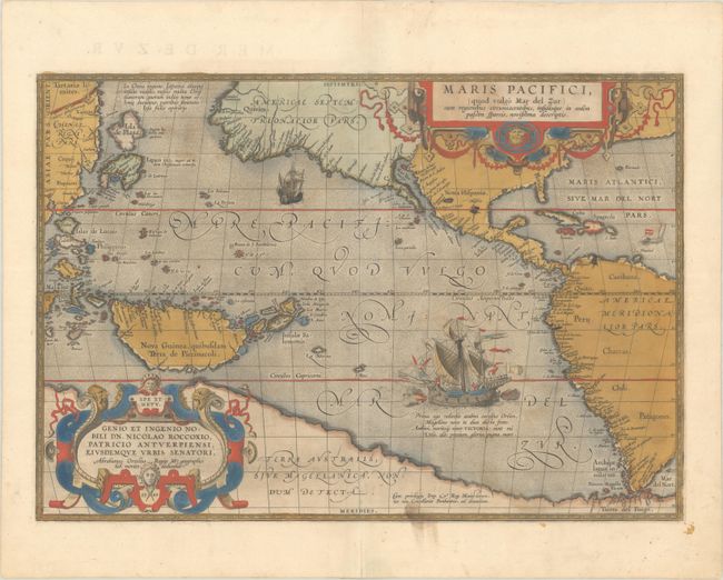
Subject: Pacific Ocean, Western Hemisphere
Period: 1589 (dated)
Publication: Theatrum Orbis Terrarum
Color: Hand Color
Size:
19.6 x 13.6 inches
49.8 x 34.5 cm
Download High Resolution Image
(or just click on image to launch the Zoom viewer)
(or just click on image to launch the Zoom viewer)
Ortelius’ seminal map of the Pacific is the first printed map devoted to the Pacific and the first to label the Americas separately as North and South subsequent to Mercator’s 1538 world map. The map draws on the cartography of Frans Hogenberg, Mercator’s world map of 1569, and Portuguese manuscript maps of Bartolomeo de Lasso. It widens the gap between Asia and North America while properly locating the Philippines and Japan, although there is an odd Isla de Plata above Japan. North America is depicted considerably narrower and more correctly at the Tropic of Cancer, and the head of the Gulf of California is shown in a new form with the R. Grande being introduced for the first time, although misplaced. The large southern continent, Terra Australis, stretches over the bottom of the map, but the name Tierra del Fuego appears south of the Strait of Magellan. The map is adorned with two elaborate cartouches and Magellan’s surviving ship Victoria is pictured along with two smaller ships. First state with the date 1589 in the lower cartouche. French text on verso, published in 1598.
See also lot 783 for John Goss' The Mapping of North America - Three Centuries of Map-Making 1500-1860 and lot 784 for Carl Wheat's Mapping the Transmississippi West that both describe this map.
References: Burden #74; Cohen, p. 31-33; Goss (NA) #14; Suarez (Pacific) p. 46, 65; Van den Broecke #12; Wheat (TMW) #24.
Condition: B+
An excellent impression with full contemporary color on a sheet with the horn coat of arms watermark commonly found on Ortelius maps. There is a bit of color offsetting, a stain along the bottom edge of the map, and a short centerfold separation at bottom that has been archivally repaired.
Estimate: $7,500 - $9,000
Current High Bid:
$0
Reserve: Reserve Not Met
Next Bid: $3,750
Bid Increments
$2,500 - $4,999$250
$5,000 - $9,999$500
$10,000 - $24,999$1,000
$25,000 - $49,999$2,500
Terms & Conditions