Current Auction
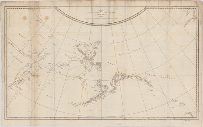
"Chart of the NW Coast of America and NE Coast of Asia Explored in the Years 1778 & 1779", Cook, James (Capt.)
Subject: North Pacific Ocean
Period: 1784 (circa)
Publication: A Voyage to the Pacific Ocean…
Color: Black & White
Size:
26.1 x 15.3 inches
66.3 x 38.9 cm
Download High Resolution Image
(or just click on image to launch the Zoom viewer)
(or just click on image to launch the Zoom viewer)
Captain James Cook (1728-1779) is best known for his three voyages to the Pacific (1768-71; 1772-75; and 1776-79). His discoveries radically changed the western understanding of the world in the late 18th century. He was the first to circumnavigate and chart New Zealand and provided the earliest European accounts of exploration along the eastern coast of Australia and the Hawaiian Islands. On February 14th, 1779, he was killed on Hawaii after attempting to kidnap the chief of the island.
Many contemporary accounts of Cook’s voyages, including charts and engravings, appeared in the late 18th century. The first official account of Cook’s first voyage was published in 1773 by John Hawkesworth in Volumes II and III of An Account of the Voyages Undertaken by the Order of His Present Majesty for Making Discoveries in the Southern Hemisphere... William Strahan and Thomas Cadell published the first official accounts of the second and third voyages in 1777 and 1784. Accounts of his exploration were subsequently translated into French, German, and Dutch.
This map presents the coastlines of northwestern North America and northeastern Asia, with particular emphasis on the region from Bristol Bay north to the Bering Strait. The detail is focused on Cook's explorations, including his third and final expedition, with his tracks shown by dotted lines. Engraved by G. Byrne.
References: Kershaw #1140, Wagner #696.
Condition: B
Issued folding with light foxing, offsetting, and minor creasing. A 5" tear at right and a few small fold separations have all been archivally repaired on verso.
Estimate: $120 - $150
Current High Bid:
$0
Reserve: Reserve Not Met
Next Bid: $60
Bid Increments
$50 - $99$5
$100 - $249$10
$250 - $499$25
$500 - $999$50
Terms & Conditions